You are here: Home > Network List > AE - Arizona Broadband Seismic Network Stations List
> Station 113A Mohawk Valley, Roll, AZ, USA > Earthquake Result Viewer
113A Mohawk Valley, Roll, AZ, USA - Earthquake Result Viewer
| Earthquake location: |
Southern Alaska |
| Earthquake latitude/longitude: |
61.3/-149.9 |
| Earthquake time(UTC): |
2018/11/30 (334) 17:29:28 GMT |
| Earthquake Depth: |
43 km |
| Earthquake Magnitude: |
6.6 ml |
| Earthquake Catalog/Contributor: |
NEIC PDE/ak |
|
| Network: |
AE Arizona Broadband Seismic Network |
| Station: |
113A Mohawk Valley, Roll, AZ, USA |
| Lat/Lon: |
32.77 N/113.77 W |
| Elevation: |
118 m |
|
| Distance: |
36.9 deg |
| Az: |
124.062 deg |
| Baz: |
331.695 deg |
| Ray Param: |
0.07634397 |
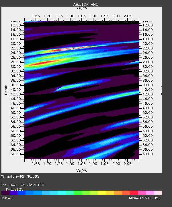
| Estimated Moho Depth: |
21.75 km |
| Estimated Crust Vp/Vs: |
1.81 |
| Assumed Crust Vp: |
6.264 km/s |
| Estimated Crust Vs: |
3.456 km/s |
| Estimated Crust Poisson's Ratio: |
0.28 |
|
| Radial Match: |
92.791565 % |
| Radial Bump: |
264 |
| Transverse Match: |
65.585594 % |
| Transverse Bump: |
400 |
| SOD ConfigId: |
13570011 |
| Insert Time: |
2019-05-01 23:11:07.197 +0000 |
| GWidth: |
2.5 |
| Max Bumps: |
400 |
| Tol: |
0.001 |
|

Signal To Noise
| Channel | StoN | STA | LTA |
| AE:113A: :HHZ:20181130T17:36:03.13001Z | 30.62176 | 1.0884674E-5 | 3.5545554E-7 |
| AE:113A: :HHN:20181130T17:36:03.13001Z | 16.2589 | 5.725917E-6 | 3.5217127E-7 |
| AE:113A: :HHE:20181130T17:36:03.13001Z | 6.0739613 | 2.381254E-6 | 3.92043E-7 |
| Arrivals |
| Ps | 3.0 SECOND |
| PpPs | 9.1 SECOND |
| PsPs/PpSs | 12 SECOND |


