You are here: Home > Network List > TA - USArray Transportable Network (new EarthScope stations) Stations List
> Station H21A Big Horn, Sheridan, WY, USA > Earthquake Result Viewer
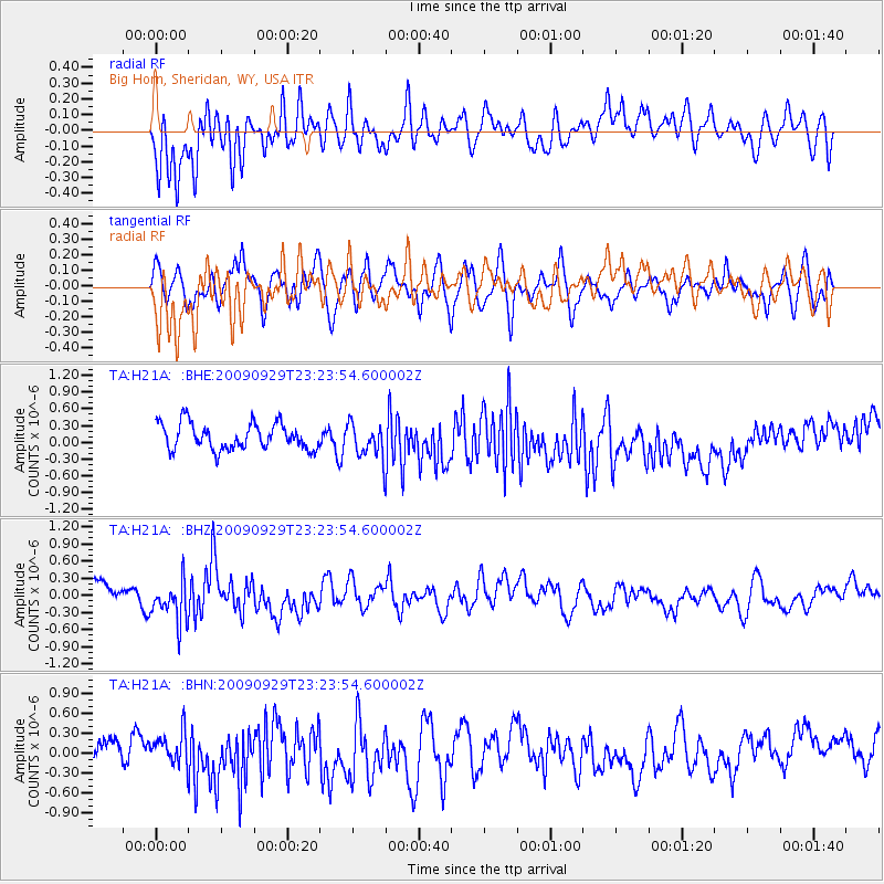
H21A Big Horn, Sheridan, WY, USA - Earthquake Result Viewer
*The percent match for this event was below the threshold and hence no stack was calculated.
| Earthquake location: |
Tonga Islands |
| Earthquake latitude/longitude: |
-15.6/-173.4 |
| Earthquake time(UTC): |
2009/09/29 (272) 23:11:51 GMT |
| Earthquake Depth: |
10 km |
| Earthquake Magnitude: |
5.5 MB |
| Earthquake Catalog/Contributor: |
WHDF/NEIC |
|
| Network: |
TA USArray Transportable Network (new EarthScope stations) |
| Station: |
H21A Big Horn, Sheridan, WY, USA |
| Lat/Lon: |
44.63 N/107.04 W |
| Elevation: |
1411 m |
|
| Distance: |
84.9 deg |
| Az: |
41.039 deg |
| Baz: |
242.382 deg |
| Ray Param: |
$rayparam |
*The percent match for this event was below the threshold and hence was not used in the summary stack. |
|
| Radial Match: |
55.267998 % |
| Radial Bump: |
400 |
| Transverse Match: |
56.63594 % |
| Transverse Bump: |
400 |
| SOD ConfigId: |
2622 |
| Insert Time: |
2010-03-06 18:21:25.323 +0000 |
| GWidth: |
2.5 |
| Max Bumps: |
400 |
| Tol: |
0.001 |
|
Signal To Noise
| Channel | StoN | STA | LTA |
| TA:H21A: :BHZ:20090929T23:23:54.600002Z | 2.0215516 | 4.016484E-7 | 1.9868322E-7 |
| TA:H21A: :BHN:20090929T23:23:54.600002Z | 1.1561009 | 2.2630233E-7 | 1.9574618E-7 |
| TA:H21A: :BHE:20090929T23:23:54.600002Z | 1.35025 | 3.1306712E-7 | 2.3185864E-7 |
| Arrivals |
| Ps | |
| PpPs | |
| PsPs/PpSs | |


