You are here: Home > Network List > CA - Catalan Seismic Network Stations List
> Station CPAL Palau-saverdera > Earthquake Result Viewer
CPAL Palau-saverdera - Earthquake Result Viewer
| Earthquake location: |
Southern Alaska |
| Earthquake latitude/longitude: |
61.3/-149.9 |
| Earthquake time(UTC): |
2018/11/30 (334) 17:29:28 GMT |
| Earthquake Depth: |
43 km |
| Earthquake Magnitude: |
6.6 ml |
| Earthquake Catalog/Contributor: |
NEIC PDE/ak |
|
| Network: |
CA Catalan Seismic Network |
| Station: |
CPAL Palau-saverdera |
| Lat/Lon: |
42.31 N/3.16 E |
| Elevation: |
212 m |
|
| Distance: |
74.4 deg |
| Az: |
20.395 deg |
| Baz: |
346.905 deg |
| Ray Param: |
0.052270494 |
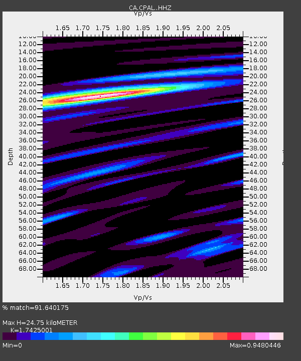
| Estimated Moho Depth: |
24.75 km |
| Estimated Crust Vp/Vs: |
1.74 |
| Assumed Crust Vp: |
6.264 km/s |
| Estimated Crust Vs: |
3.595 km/s |
| Estimated Crust Poisson's Ratio: |
0.25 |
|
| Radial Match: |
91.640175 % |
| Radial Bump: |
387 |
| Transverse Match: |
80.00081 % |
| Transverse Bump: |
400 |
| SOD ConfigId: |
13570011 |
| Insert Time: |
2019-05-01 23:12:01.458 +0000 |
| GWidth: |
2.5 |
| Max Bumps: |
400 |
| Tol: |
0.001 |
|

Signal To Noise
| Channel | StoN | STA | LTA |
| CA:CPAL: :HHZ:20181130T17:40:31.469976Z | 24.847307 | 1.2921566E-5 | 5.200389E-7 |
| CA:CPAL: :HHN:20181130T17:40:31.469976Z | 12.221432 | 5.302158E-6 | 4.33841E-7 |
| CA:CPAL: :HHE:20181130T17:40:31.469976Z | 6.1394935 | 2.059196E-6 | 3.354016E-7 |
| Arrivals |
| Ps | 3.0 SECOND |
| PpPs | 10 SECOND |
| PsPs/PpSs | 14 SECOND |


