You are here: Home > Network List > TA - USArray Transportable Network (new EarthScope stations) Stations List
> Station H21A Big Horn, Sheridan, WY, USA > Earthquake Result Viewer
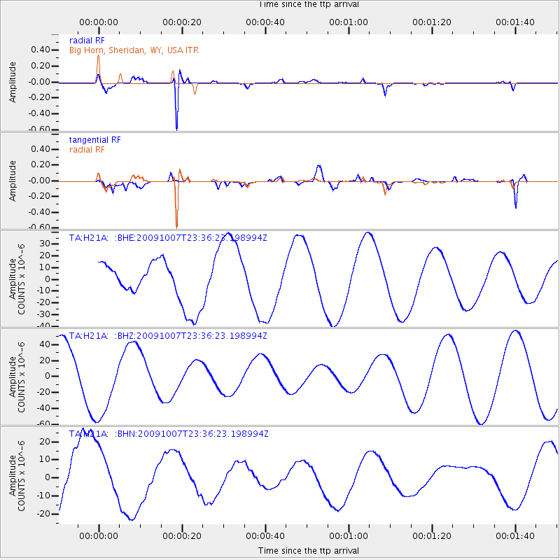
H21A Big Horn, Sheridan, WY, USA - Earthquake Result Viewer
*The percent match for this event was below the threshold and hence no stack was calculated.
| Earthquake location: |
Santa Cruz Islands |
| Earthquake latitude/longitude: |
-12.6/166.0 |
| Earthquake time(UTC): |
2009/10/07 (280) 23:23:28 GMT |
| Earthquake Depth: |
36 km |
| Earthquake Magnitude: |
5.5 MB |
| Earthquake Catalog/Contributor: |
WHDF/NEIC |
|
| Network: |
TA USArray Transportable Network (new EarthScope stations) |
| Station: |
H21A Big Horn, Sheridan, WY, USA |
| Lat/Lon: |
44.63 N/107.04 W |
| Elevation: |
1411 m |
|
| Distance: |
96.6 deg |
| Az: |
45.874 deg |
| Baz: |
258.967 deg |
| Ray Param: |
$rayparam |
*The percent match for this event was below the threshold and hence was not used in the summary stack. |
|
| Radial Match: |
69.61082 % |
| Radial Bump: |
220 |
| Transverse Match: |
68.28529 % |
| Transverse Bump: |
400 |
| SOD ConfigId: |
2622 |
| Insert Time: |
2010-03-06 18:21:34.094 +0000 |
| GWidth: |
2.5 |
| Max Bumps: |
400 |
| Tol: |
0.001 |
|
Signal To Noise
| Channel | StoN | STA | LTA |
| TA:H21A: :BHZ:20091007T23:36:23.198994Z | 1.6162144 | 4.638728E-5 | 2.870119E-5 |
| TA:H21A: :BHN:20091007T23:36:23.198994Z | 0.73408675 | 1.5036785E-5 | 2.0483663E-5 |
| TA:H21A: :BHE:20091007T23:36:23.198994Z | 2.015161 | 3.5121437E-5 | 1.74286E-5 |
| Arrivals |
| Ps | |
| PpPs | |
| PsPs/PpSs | |


