You are here: Home > Network List > TA - USArray Transportable Network (new EarthScope stations) Stations List
> Station H21A Big Horn, Sheridan, WY, USA > Earthquake Result Viewer
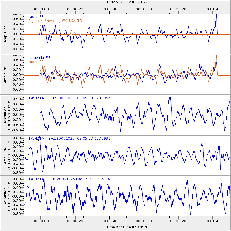
H21A Big Horn, Sheridan, WY, USA - Earthquake Result Viewer
*The percent match for this event was below the threshold and hence no stack was calculated.
| Earthquake location: |
South Of Fiji Islands |
| Earthquake latitude/longitude: |
-23.1/-179.2 |
| Earthquake time(UTC): |
2009/10/25 (298) 07:53:52 GMT |
| Earthquake Depth: |
418 km |
| Earthquake Magnitude: |
5.6 MB, 6.0 MW, 5.9 MW |
| Earthquake Catalog/Contributor: |
WHDF/NEIC |
|
| Network: |
TA USArray Transportable Network (new EarthScope stations) |
| Station: |
H21A Big Horn, Sheridan, WY, USA |
| Lat/Lon: |
44.63 N/107.04 W |
| Elevation: |
1411 m |
|
| Distance: |
94.1 deg |
| Az: |
42.958 deg |
| Baz: |
241.5 deg |
| Ray Param: |
$rayparam |
*The percent match for this event was below the threshold and hence was not used in the summary stack. |
|
| Radial Match: |
54.026085 % |
| Radial Bump: |
400 |
| Transverse Match: |
45.790676 % |
| Transverse Bump: |
400 |
| SOD ConfigId: |
2622 |
| Insert Time: |
2010-03-06 18:21:39.043 +0000 |
| GWidth: |
2.5 |
| Max Bumps: |
400 |
| Tol: |
0.001 |
|
Signal To Noise
| Channel | StoN | STA | LTA |
| TA:H21A: :BHZ:20091025T08:05:53.123999Z | 3.2933395 | 4.7679555E-7 | 1.4477571E-7 |
| TA:H21A: :BHN:20091025T08:05:53.123999Z | 1.6609839 | 4.3393516E-7 | 2.6125187E-7 |
| TA:H21A: :BHE:20091025T08:05:53.123999Z | 1.1361449 | 3.7987306E-7 | 3.3435265E-7 |
| Arrivals |
| Ps | |
| PpPs | |
| PsPs/PpSs | |


