You are here: Home > Network List > CI - Caltech Regional Seismic Network Stations List
> Station FMP Fort MacArthur Park, Pt. Fermin San Pedro, CA, USA > Earthquake Result Viewer
FMP Fort MacArthur Park, Pt. Fermin San Pedro, CA, USA - Earthquake Result Viewer
| Earthquake location: |
Southern Alaska |
| Earthquake latitude/longitude: |
61.3/-149.9 |
| Earthquake time(UTC): |
2018/11/30 (334) 17:29:28 GMT |
| Earthquake Depth: |
43 km |
| Earthquake Magnitude: |
6.6 ml |
| Earthquake Catalog/Contributor: |
NEIC PDE/ak |
|
| Network: |
CI Caltech Regional Seismic Network |
| Station: |
FMP Fort MacArthur Park, Pt. Fermin San Pedro, CA, USA |
| Lat/Lon: |
33.71 N/118.29 W |
| Elevation: |
89 m |
|
| Distance: |
34.3 deg |
| Az: |
129.1 deg |
| Baz: |
333.323 deg |
| Ray Param: |
0.077724025 |
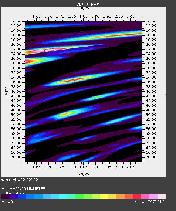
| Estimated Moho Depth: |
22.25 km |
| Estimated Crust Vp/Vs: |
1.68 |
| Assumed Crust Vp: |
6.048 km/s |
| Estimated Crust Vs: |
3.595 km/s |
| Estimated Crust Poisson's Ratio: |
0.23 |
|
| Radial Match: |
82.32132 % |
| Radial Bump: |
400 |
| Transverse Match: |
74.153824 % |
| Transverse Bump: |
400 |
| SOD ConfigId: |
13570011 |
| Insert Time: |
2019-05-01 23:12:36.000 +0000 |
| GWidth: |
2.5 |
| Max Bumps: |
400 |
| Tol: |
0.001 |
|

Signal To Noise
| Channel | StoN | STA | LTA |
| CI:FMP: :HHZ:20181130T17:35:40.988011Z | 11.6176605 | 1.0323202E-5 | 8.885784E-7 |
| CI:FMP: :HHN:20181130T17:35:40.988011Z | 3.827895 | 6.1023547E-6 | 1.5941803E-6 |
| CI:FMP: :HHE:20181130T17:35:40.988011Z | 1.821185 | 3.8585395E-6 | 2.118697E-6 |
| Arrivals |
| Ps | 2.7 SECOND |
| PpPs | 9.2 SECOND |
| PsPs/PpSs | 12 SECOND |


