You are here: Home > Network List > TS - TERRAscope (Southern California Seismic Network) Stations List
> Station BAR Barrett Dam, California, USA > Earthquake Result Viewer
BAR Barrett Dam, California, USA - Earthquake Result Viewer
*The percent match for this event was below the threshold and hence no stack was calculated.
| Earthquake location: |
D'Entrecasteaux Islands Region |
| Earthquake latitude/longitude: |
-9.5/152.1 |
| Earthquake time(UTC): |
1994/02/17 (048) 21:52:47 GMT |
| Earthquake Depth: |
25 km |
| Earthquake Magnitude: |
5.8 MS, 5.2 MB |
| Earthquake Catalog/Contributor: |
WHDF/NEIC |
|
| Network: |
TS TERRAscope (Southern California Seismic Network) |
| Station: |
BAR Barrett Dam, California, USA |
| Lat/Lon: |
32.68 N/116.67 W |
| Elevation: |
548 m |
|
| Distance: |
96.1 deg |
| Az: |
57.989 deg |
| Baz: |
262.698 deg |
| Ray Param: |
$rayparam |
*The percent match for this event was below the threshold and hence was not used in the summary stack. |
|
| Radial Match: |
58.713173 % |
| Radial Bump: |
400 |
| Transverse Match: |
60.26903 % |
| Transverse Bump: |
400 |
| SOD ConfigId: |
4480 |
| Insert Time: |
2010-02-26 14:01:19.761 +0000 |
| GWidth: |
2.5 |
| Max Bumps: |
400 |
| Tol: |
0.001 |
|
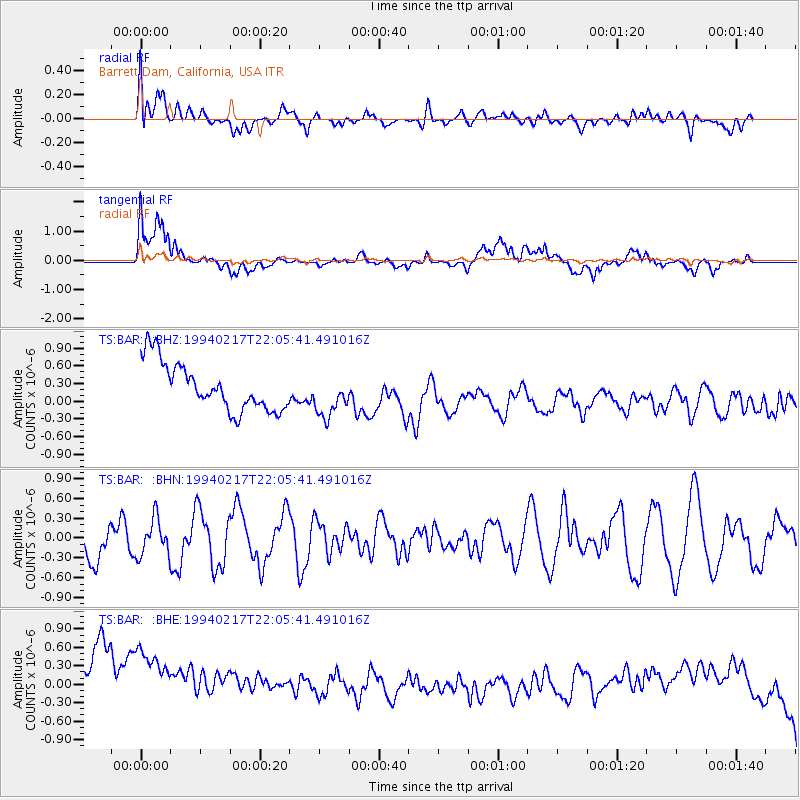
Signal To Noise
| Channel | StoN | STA | LTA |
| TS:BAR: :BHN:19940217T22:05:41.491016Z | 0.8303113 | 2.8642046E-7 | 3.449555E-7 |
| TS:BAR: :BHE:19940217T22:05:41.491016Z | 0.88334566 | 1.5908095E-6 | 1.8008913E-6 |
| TS:BAR: :BHZ:19940217T22:05:41.491016Z | 0.9308051 | 3.7645853E-7 | 4.04444E-7 |
| Arrivals |
| Ps | |
| PpPs | |
| PsPs/PpSs | |


