You are here: Home > Network List > EI - Irish National Seismic Network (INSN) Stations List
> Station IDGL INCH ISLAND, CO DONEGAL, IRELAND > Earthquake Result Viewer
IDGL INCH ISLAND, CO DONEGAL, IRELAND - Earthquake Result Viewer
| Earthquake location: |
Southern Alaska |
| Earthquake latitude/longitude: |
61.3/-149.9 |
| Earthquake time(UTC): |
2018/11/30 (334) 17:29:28 GMT |
| Earthquake Depth: |
43 km |
| Earthquake Magnitude: |
6.6 ml |
| Earthquake Catalog/Contributor: |
NEIC PDE/ak |
|
| Network: |
EI Irish National Seismic Network (INSN) |
| Station: |
IDGL INCH ISLAND, CO DONEGAL, IRELAND |
| Lat/Lon: |
55.07 N/7.51 W |
| Elevation: |
123 m |
|
| Distance: |
60.2 deg |
| Az: |
23.839 deg |
| Baz: |
340.19 deg |
| Ray Param: |
0.06159652 |
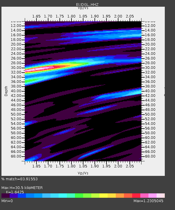
| Estimated Moho Depth: |
30.5 km |
| Estimated Crust Vp/Vs: |
1.64 |
| Assumed Crust Vp: |
6.276 km/s |
| Estimated Crust Vs: |
3.821 km/s |
| Estimated Crust Poisson's Ratio: |
0.21 |
|
| Radial Match: |
83.91553 % |
| Radial Bump: |
344 |
| Transverse Match: |
64.60912 % |
| Transverse Bump: |
400 |
| SOD ConfigId: |
13570011 |
| Insert Time: |
2019-05-01 23:13:58.994 +0000 |
| GWidth: |
2.5 |
| Max Bumps: |
400 |
| Tol: |
0.001 |
|

Signal To Noise
| Channel | StoN | STA | LTA |
| EI:IDGL: :HHZ:20181130T17:39:01.789983Z | 8.232661 | 2.0862508E-5 | 2.5341149E-6 |
| EI:IDGL: :HHN:20181130T17:39:01.789983Z | 4.981319 | 5.555807E-6 | 1.1153285E-6 |
| EI:IDGL: :HHE:20181130T17:39:01.789983Z | 2.7875881 | 4.0329182E-6 | 1.4467412E-6 |
| Arrivals |
| Ps | 3.3 SECOND |
| PpPs | 12 SECOND |
| PsPs/PpSs | 16 SECOND |


