You are here: Home > Network List > LD - Lamont-Doherty Cooperative Seismographic Network Stations List
> Station BRNJ Basking Ridge, New Jersey > Earthquake Result Viewer
BRNJ Basking Ridge, New Jersey - Earthquake Result Viewer
| Earthquake location: |
Southern Alaska |
| Earthquake latitude/longitude: |
61.3/-149.9 |
| Earthquake time(UTC): |
2018/11/30 (334) 17:29:28 GMT |
| Earthquake Depth: |
43 km |
| Earthquake Magnitude: |
6.6 ml |
| Earthquake Catalog/Contributor: |
NEIC PDE/ak |
|
| Network: |
LD Lamont-Doherty Cooperative Seismographic Network |
| Station: |
BRNJ Basking Ridge, New Jersey |
| Lat/Lon: |
40.68 N/74.57 W |
| Elevation: |
50 m |
|
| Distance: |
48.6 deg |
| Az: |
78.868 deg |
| Baz: |
321.525 deg |
| Ray Param: |
0.06916075 |
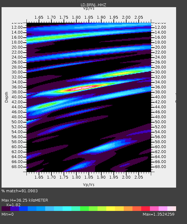
| Estimated Moho Depth: |
36.25 km |
| Estimated Crust Vp/Vs: |
1.82 |
| Assumed Crust Vp: |
6.283 km/s |
| Estimated Crust Vs: |
3.452 km/s |
| Estimated Crust Poisson's Ratio: |
0.28 |
|
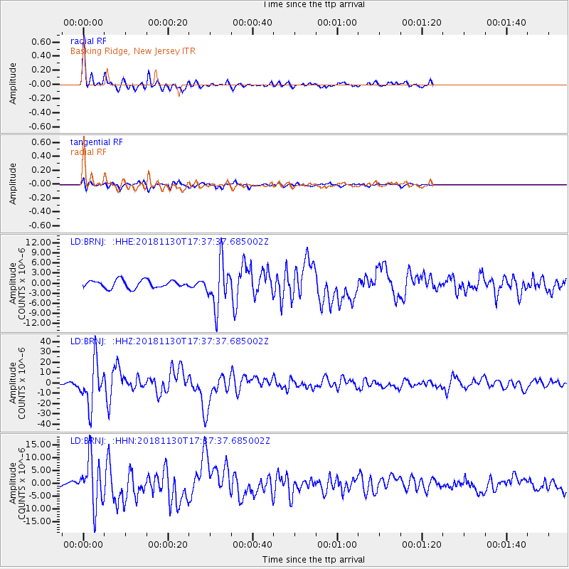
| Radial Match: |
91.0983 % |
| Radial Bump: |
261 |
| Transverse Match: |
76.52286 % |
| Transverse Bump: |
400 |
| SOD ConfigId: |
13570011 |
| Insert Time: |
2019-05-01 23:16:10.606 +0000 |
| GWidth: |
2.5 |
| Max Bumps: |
400 |
| Tol: |
0.001 |
|
Signal To Noise
| Channel | StoN | STA | LTA |
| LD:BRNJ: :HHZ:20181130T17:37:37.685002Z | 12.999201 | 2.1235752E-5 | 1.6336197E-6 |
| LD:BRNJ: :HHN:20181130T17:37:37.685002Z | 9.961773 | 9.453261E-6 | 9.4895364E-7 |
| LD:BRNJ: :HHE:20181130T17:37:37.685002Z | 5.8117113 | 6.682154E-6 | 1.149774E-6 |
| Arrivals |
| Ps | 5.0 SECOND |
| PpPs | 15 SECOND |
| PsPs/PpSs | 20 SECOND |


