You are here: Home > Network List > LD - Lamont-Doherty Cooperative Seismographic Network Stations List
> Station BRNY Black Rock Forest, Cornwall, NY > Earthquake Result Viewer
BRNY Black Rock Forest, Cornwall, NY - Earthquake Result Viewer
| Earthquake location: |
Southern Alaska |
| Earthquake latitude/longitude: |
61.3/-149.9 |
| Earthquake time(UTC): |
2018/11/30 (334) 17:29:28 GMT |
| Earthquake Depth: |
43 km |
| Earthquake Magnitude: |
6.6 ml |
| Earthquake Catalog/Contributor: |
NEIC PDE/ak |
|
| Network: |
LD Lamont-Doherty Cooperative Seismographic Network |
| Station: |
BRNY Black Rock Forest, Cornwall, NY |
| Lat/Lon: |
41.41 N/74.01 W |
| Elevation: |
248 m |
|
| Distance: |
48.3 deg |
| Az: |
77.82 deg |
| Baz: |
321.192 deg |
| Ray Param: |
0.069367036 |
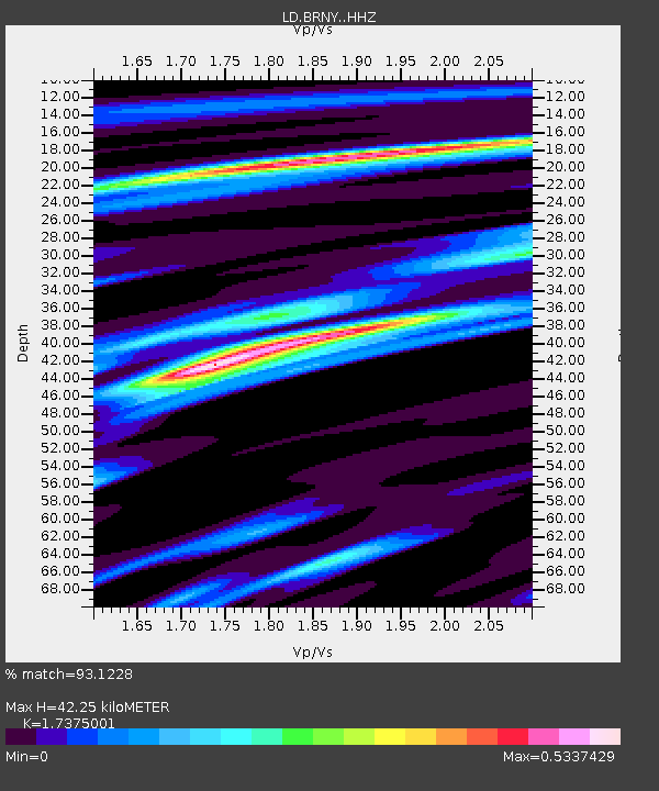
| Estimated Moho Depth: |
42.25 km |
| Estimated Crust Vp/Vs: |
1.74 |
| Assumed Crust Vp: |
6.283 km/s |
| Estimated Crust Vs: |
3.616 km/s |
| Estimated Crust Poisson's Ratio: |
0.25 |
|
| Radial Match: |
93.1228 % |
| Radial Bump: |
184 |
| Transverse Match: |
75.5984 % |
| Transverse Bump: |
307 |
| SOD ConfigId: |
13570011 |
| Insert Time: |
2019-05-01 23:16:11.047 +0000 |
| GWidth: |
2.5 |
| Max Bumps: |
400 |
| Tol: |
0.001 |
|

Signal To Noise
| Channel | StoN | STA | LTA |
| LD:BRNY: :HHZ:20181130T17:37:35.310002Z | 16.666891 | 1.7347276E-5 | 1.0408226E-6 |
| LD:BRNY: :HHN:20181130T17:37:35.310002Z | 16.718033 | 5.652952E-6 | 3.3813498E-7 |
| LD:BRNY: :HHE:20181130T17:37:35.310002Z | 7.18398 | 5.7406596E-6 | 7.990918E-7 |
| Arrivals |
| Ps | 5.3 SECOND |
| PpPs | 17 SECOND |
| PsPs/PpSs | 23 SECOND |


