You are here: Home > Network List > LD - Lamont-Doherty Cooperative Seismographic Network Stations List
> Station HCNY Howe Caverns, Cobleskill, NY > Earthquake Result Viewer
HCNY Howe Caverns, Cobleskill, NY - Earthquake Result Viewer
| Earthquake location: |
Southern Alaska |
| Earthquake latitude/longitude: |
61.3/-149.9 |
| Earthquake time(UTC): |
2018/11/30 (334) 17:29:28 GMT |
| Earthquake Depth: |
43 km |
| Earthquake Magnitude: |
6.6 ml |
| Earthquake Catalog/Contributor: |
NEIC PDE/ak |
|
| Network: |
LD Lamont-Doherty Cooperative Seismographic Network |
| Station: |
HCNY Howe Caverns, Cobleskill, NY |
| Lat/Lon: |
42.70 N/74.40 W |
| Elevation: |
273 m |
|
| Distance: |
47.1 deg |
| Az: |
77.026 deg |
| Baz: |
320.4 deg |
| Ray Param: |
0.07010977 |
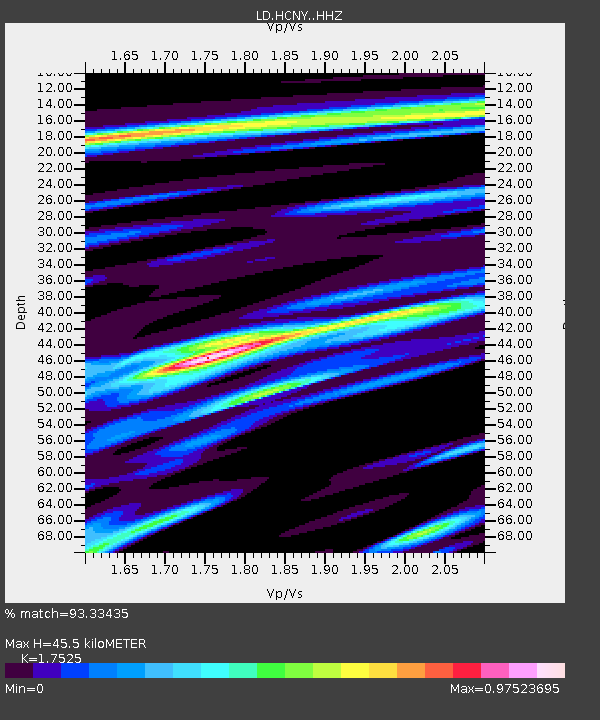
| Estimated Moho Depth: |
45.5 km |
| Estimated Crust Vp/Vs: |
1.75 |
| Assumed Crust Vp: |
6.419 km/s |
| Estimated Crust Vs: |
3.663 km/s |
| Estimated Crust Poisson's Ratio: |
0.26 |
|
| Radial Match: |
93.33435 % |
| Radial Bump: |
286 |
| Transverse Match: |
60.51986 % |
| Transverse Bump: |
386 |
| SOD ConfigId: |
13570011 |
| Insert Time: |
2019-05-01 23:16:19.218 +0000 |
| GWidth: |
2.5 |
| Max Bumps: |
400 |
| Tol: |
0.001 |
|

Signal To Noise
| Channel | StoN | STA | LTA |
| LD:HCNY: :HHZ:20181130T17:37:26.215001Z | 27.436056 | 1.7555898E-5 | 6.3988415E-7 |
| LD:HCNY: :HHN:20181130T17:37:26.215001Z | 9.282618 | 8.364899E-6 | 9.011359E-7 |
| LD:HCNY: :HHE:20181130T17:37:26.215001Z | 13.145318 | 6.5760078E-6 | 5.002547E-7 |
| Arrivals |
| Ps | 5.7 SECOND |
| PpPs | 18 SECOND |
| PsPs/PpSs | 24 SECOND |


