You are here: Home > Network List > MU - Miami University Seismic Network Stations List
> Station MUB2 Belmont > Earthquake Result Viewer
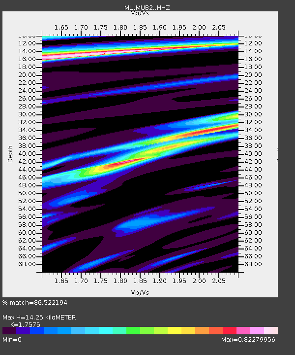
MUB2 Belmont - Earthquake Result Viewer
| Earthquake location: |
Southern Alaska |
| Earthquake latitude/longitude: |
61.3/-149.9 |
| Earthquake time(UTC): |
2018/11/30 (334) 17:29:28 GMT |
| Earthquake Depth: |
43 km |
| Earthquake Magnitude: |
6.6 ml |
| Earthquake Catalog/Contributor: |
NEIC PDE/ak |
|
| Network: |
MU Miami University Seismic Network |
| Station: |
MUB2 Belmont |
| Lat/Lon: |
40.08 N/80.90 W |
| Elevation: |
384 m |
|
| Distance: |
46.0 deg |
| Az: |
84.519 deg |
| Baz: |
321.269 deg |
| Ray Param: |
0.0707975 |
| Estimated Moho Depth: |
14.25 km |
| Estimated Crust Vp/Vs: |
1.76 |
| Assumed Crust Vp: |
6.483 km/s |
| Estimated Crust Vs: |
3.689 km/s |
| Estimated Crust Poisson's Ratio: |
0.26 |
|
| Radial Match: |
86.522194 % |
| Radial Bump: |
332 |
| Transverse Match: |
65.82876 % |
| Transverse Bump: |
400 |
| SOD ConfigId: |
13570011 |
| Insert Time: |
2019-05-01 23:16:48.712 +0000 |
| GWidth: |
2.5 |
| Max Bumps: |
400 |
| Tol: |
0.001 |
|

Signal To Noise
| Channel | StoN | STA | LTA |
| MU:MUB2: :HHZ:20181130T17:37:17.88001Z | 10.670382 | 3.9547434E-5 | 3.7062814E-6 |
| MU:MUB2: :HHN:20181130T17:37:17.88001Z | 5.965669 | 2.1283904E-5 | 3.5677315E-6 |
| MU:MUB2: :HHE:20181130T17:37:17.88001Z | 7.462926 | 1.4360215E-5 | 1.924207E-6 |
| Arrivals |
| Ps | 1.8 SECOND |
| PpPs | 5.7 SECOND |
| PsPs/PpSs | 7.5 SECOND |


