You are here: Home > Network List > MU - Miami University Seismic Network Stations List
> Station MUG1 Guernsy > Earthquake Result Viewer
MUG1 Guernsy - Earthquake Result Viewer
| Earthquake location: |
Southern Alaska |
| Earthquake latitude/longitude: |
61.3/-149.9 |
| Earthquake time(UTC): |
2018/11/30 (334) 17:29:28 GMT |
| Earthquake Depth: |
43 km |
| Earthquake Magnitude: |
6.6 ml |
| Earthquake Catalog/Contributor: |
NEIC PDE/ak |
|
| Network: |
MU Miami University Seismic Network |
| Station: |
MUG1 Guernsy |
| Lat/Lon: |
40.11 N/81.29 W |
| Elevation: |
368 m |
|
| Distance: |
45.8 deg |
| Az: |
84.823 deg |
| Baz: |
321.228 deg |
| Ray Param: |
0.07092766 |
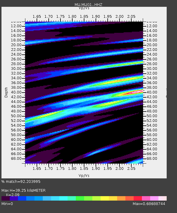
| Estimated Moho Depth: |
39.25 km |
| Estimated Crust Vp/Vs: |
2.09 |
| Assumed Crust Vp: |
6.483 km/s |
| Estimated Crust Vs: |
3.102 km/s |
| Estimated Crust Poisson's Ratio: |
0.35 |
|
| Radial Match: |
92.203995 % |
| Radial Bump: |
300 |
| Transverse Match: |
71.0858 % |
| Transverse Bump: |
400 |
| SOD ConfigId: |
13570011 |
| Insert Time: |
2019-05-01 23:16:48.882 +0000 |
| GWidth: |
2.5 |
| Max Bumps: |
400 |
| Tol: |
0.001 |
|

Signal To Noise
| Channel | StoN | STA | LTA |
| MU:MUG1: :HHZ:20181130T17:37:16.220006Z | 17.045622 | 4.5303215E-5 | 2.6577625E-6 |
| MU:MUG1: :HHN:20181130T17:37:16.220006Z | 5.2321444 | 2.1858828E-5 | 4.1777953E-6 |
| MU:MUG1: :HHE:20181130T17:37:16.220006Z | 8.228664 | 1.7541774E-5 | 2.1317885E-6 |
| Arrivals |
| Ps | 7.0 SECOND |
| PpPs | 18 SECOND |
| PsPs/PpSs | 25 SECOND |


