You are here: Home > Network List > N4 - Central and EAstern US Network Stations List
> Station F64A Sherman, ME, USA > Earthquake Result Viewer
F64A Sherman, ME, USA - Earthquake Result Viewer
| Earthquake location: |
Southern Alaska |
| Earthquake latitude/longitude: |
61.3/-149.9 |
| Earthquake time(UTC): |
2018/11/30 (334) 17:29:28 GMT |
| Earthquake Depth: |
43 km |
| Earthquake Magnitude: |
6.6 ml |
| Earthquake Catalog/Contributor: |
NEIC PDE/ak |
|
| Network: |
N4 Central and EAstern US Network |
| Station: |
F64A Sherman, ME, USA |
| Lat/Lon: |
45.86 N/68.35 W |
| Elevation: |
179 m |
|
| Distance: |
47.5 deg |
| Az: |
69.728 deg |
| Baz: |
319.657 deg |
| Ray Param: |
0.069869295 |
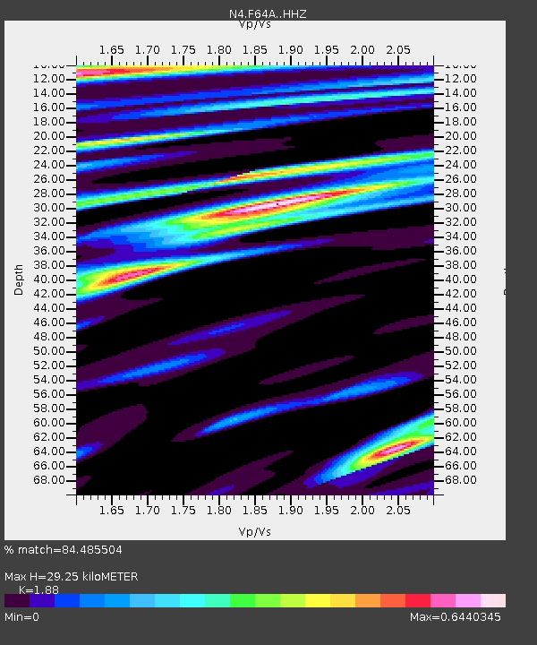
| Estimated Moho Depth: |
29.25 km |
| Estimated Crust Vp/Vs: |
1.88 |
| Assumed Crust Vp: |
6.419 km/s |
| Estimated Crust Vs: |
3.414 km/s |
| Estimated Crust Poisson's Ratio: |
0.30 |
|
| Radial Match: |
84.485504 % |
| Radial Bump: |
226 |
| Transverse Match: |
67.16163 % |
| Transverse Bump: |
308 |
| SOD ConfigId: |
13570011 |
| Insert Time: |
2019-05-01 23:17:15.107 +0000 |
| GWidth: |
2.5 |
| Max Bumps: |
400 |
| Tol: |
0.001 |
|

Signal To Noise
| Channel | StoN | STA | LTA |
| N4:F64A: :HHZ:20181130T17:37:29.049993Z | 16.138351 | 2.1178099E-5 | 1.3122839E-6 |
| N4:F64A: :HHN:20181130T17:37:29.049993Z | 7.8066645 | 6.9168927E-6 | 8.860241E-7 |
| N4:F64A: :HHE:20181130T17:37:29.049993Z | 5.020757 | 5.127251E-6 | 1.0212107E-6 |
| Arrivals |
| Ps | 4.2 SECOND |
| PpPs | 12 SECOND |
| PsPs/PpSs | 17 SECOND |


