You are here: Home > Network List > N4 - Central and EAstern US Network Stations List
> Station I37B Waseca, MN, USA > Earthquake Result Viewer
I37B Waseca, MN, USA - Earthquake Result Viewer
| Earthquake location: |
Southern Alaska |
| Earthquake latitude/longitude: |
61.3/-149.9 |
| Earthquake time(UTC): |
2018/11/30 (334) 17:29:28 GMT |
| Earthquake Depth: |
43 km |
| Earthquake Magnitude: |
6.6 ml |
| Earthquake Catalog/Contributor: |
NEIC PDE/ak |
|
| Network: |
N4 Central and EAstern US Network |
| Station: |
I37B Waseca, MN, USA |
| Lat/Lon: |
44.01 N/93.40 W |
| Elevation: |
354 m |
|
| Distance: |
37.0 deg |
| Az: |
91.397 deg |
| Baz: |
318.073 deg |
| Ray Param: |
0.07626967 |
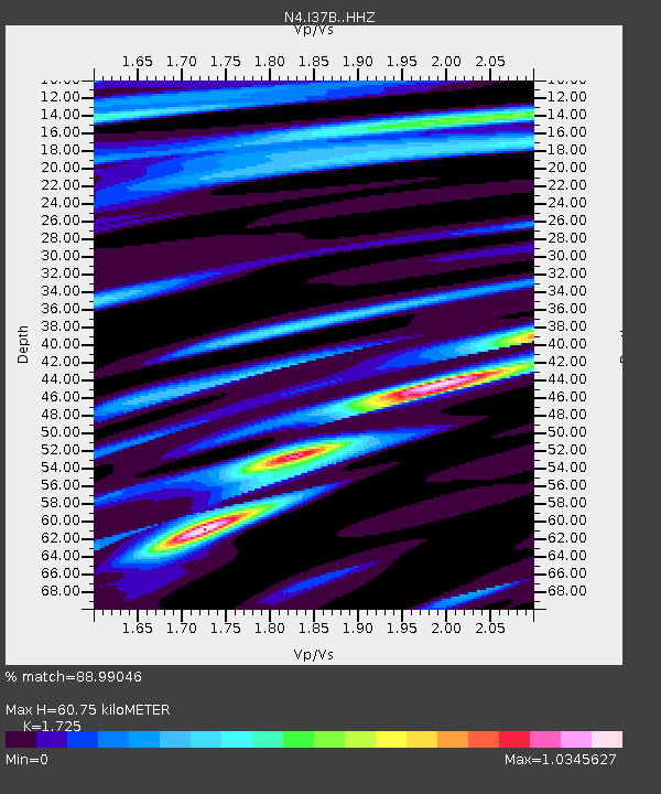
| Estimated Moho Depth: |
60.75 km |
| Estimated Crust Vp/Vs: |
1.73 |
| Assumed Crust Vp: |
6.571 km/s |
| Estimated Crust Vs: |
3.809 km/s |
| Estimated Crust Poisson's Ratio: |
0.25 |
|
| Radial Match: |
88.99046 % |
| Radial Bump: |
328 |
| Transverse Match: |
75.94947 % |
| Transverse Bump: |
396 |
| SOD ConfigId: |
13570011 |
| Insert Time: |
2019-05-01 23:17:19.696 +0000 |
| GWidth: |
2.5 |
| Max Bumps: |
400 |
| Tol: |
0.001 |
|

Signal To Noise
| Channel | StoN | STA | LTA |
| N4:I37B: :HHZ:20181130T17:36:04.239995Z | 23.163862 | 3.1797343E-5 | 1.3727133E-6 |
| N4:I37B: :HHN:20181130T17:36:04.239995Z | 6.3430796 | 1.0317034E-5 | 1.6265024E-6 |
| N4:I37B: :HHE:20181130T17:36:04.239995Z | 9.541352 | 9.924779E-6 | 1.0401858E-6 |
| Arrivals |
| Ps | 7.3 SECOND |
| PpPs | 23 SECOND |
| PsPs/PpSs | 31 SECOND |


