You are here: Home > Network List > N4 - Central and EAstern US Network Stations List
> Station J47A Sunmer, MI, USA > Earthquake Result Viewer
J47A Sunmer, MI, USA - Earthquake Result Viewer
| Earthquake location: |
Southern Alaska |
| Earthquake latitude/longitude: |
61.3/-149.9 |
| Earthquake time(UTC): |
2018/11/30 (334) 17:29:28 GMT |
| Earthquake Depth: |
43 km |
| Earthquake Magnitude: |
6.6 ml |
| Earthquake Catalog/Contributor: |
NEIC PDE/ak |
|
| Network: |
N4 Central and EAstern US Network |
| Station: |
J47A Sunmer, MI, USA |
| Lat/Lon: |
43.24 N/84.82 W |
| Elevation: |
236 m |
|
| Distance: |
41.7 deg |
| Az: |
84.855 deg |
| Baz: |
318.913 deg |
| Ray Param: |
0.07350037 |
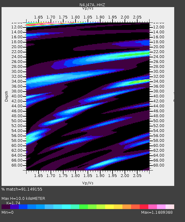
| Estimated Moho Depth: |
10.0 km |
| Estimated Crust Vp/Vs: |
1.74 |
| Assumed Crust Vp: |
6.483 km/s |
| Estimated Crust Vs: |
3.726 km/s |
| Estimated Crust Poisson's Ratio: |
0.25 |
|
| Radial Match: |
91.149155 % |
| Radial Bump: |
361 |
| Transverse Match: |
67.43847 % |
| Transverse Bump: |
400 |
| SOD ConfigId: |
13570011 |
| Insert Time: |
2019-05-01 23:17:25.196 +0000 |
| GWidth: |
2.5 |
| Max Bumps: |
400 |
| Tol: |
0.001 |
|

Signal To Noise
| Channel | StoN | STA | LTA |
| N4:J47A: :HHZ:20181130T17:36:43.429998Z | 16.147352 | 1.7025579E-5 | 1.0543882E-6 |
| N4:J47A: :HHN:20181130T17:36:43.429998Z | 7.6036315 | 7.0799315E-6 | 9.3112504E-7 |
| N4:J47A: :HHE:20181130T17:36:43.429998Z | 9.374711 | 7.1131817E-6 | 7.587627E-7 |
| Arrivals |
| Ps | 1.2 SECOND |
| PpPs | 3.9 SECOND |
| PsPs/PpSs | 5.2 SECOND |


