You are here: Home > Network List > N4 - Central and EAstern US Network Stations List
> Station KSCO Kaye's Shedlock's, Cheyenne Wells, CO, USA > Earthquake Result Viewer
KSCO Kaye's Shedlock's, Cheyenne Wells, CO, USA - Earthquake Result Viewer
| Earthquake location: |
Southern Alaska |
| Earthquake latitude/longitude: |
61.3/-149.9 |
| Earthquake time(UTC): |
2018/11/30 (334) 17:29:28 GMT |
| Earthquake Depth: |
43 km |
| Earthquake Magnitude: |
6.6 ml |
| Earthquake Catalog/Contributor: |
NEIC PDE/ak |
|
| Network: |
N4 Central and EAstern US Network |
| Station: |
KSCO Kaye's Shedlock's, Cheyenne Wells, CO, USA |
| Lat/Lon: |
39.01 N/102.63 W |
| Elevation: |
1382 m |
|
| Distance: |
36.5 deg |
| Az: |
105.66 deg |
| Baz: |
323.416 deg |
| Ray Param: |
0.07655605 |
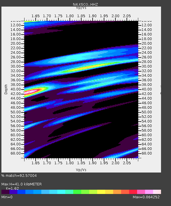
| Estimated Moho Depth: |
41.0 km |
| Estimated Crust Vp/Vs: |
1.62 |
| Assumed Crust Vp: |
6.242 km/s |
| Estimated Crust Vs: |
3.853 km/s |
| Estimated Crust Poisson's Ratio: |
0.19 |
|
| Radial Match: |
92.57004 % |
| Radial Bump: |
281 |
| Transverse Match: |
62.44091 % |
| Transverse Bump: |
400 |
| SOD ConfigId: |
13570011 |
| Insert Time: |
2019-05-01 23:17:33.037 +0000 |
| GWidth: |
2.5 |
| Max Bumps: |
400 |
| Tol: |
0.001 |
|

Signal To Noise
| Channel | StoN | STA | LTA |
| N4:KSCO: :HHZ:20181130T17:35:59.790013Z | 33.883717 | 1.4006633E-5 | 4.133736E-7 |
| N4:KSCO: :HHN:20181130T17:35:59.790013Z | 13.473174 | 8.0746895E-6 | 5.99316E-7 |
| N4:KSCO: :HHE:20181130T17:35:59.790013Z | 7.280427 | 5.7681937E-6 | 7.9228784E-7 |
| Arrivals |
| Ps | 4.4 SECOND |
| PpPs | 16 SECOND |
| PsPs/PpSs | 20 SECOND |


