You are here: Home > Network List > N4 - Central and EAstern US Network Stations List
> Station M52A Chesterland, OH, USA > Earthquake Result Viewer
M52A Chesterland, OH, USA - Earthquake Result Viewer
| Earthquake location: |
Southern Alaska |
| Earthquake latitude/longitude: |
61.3/-149.9 |
| Earthquake time(UTC): |
2018/11/30 (334) 17:29:28 GMT |
| Earthquake Depth: |
43 km |
| Earthquake Magnitude: |
6.6 ml |
| Earthquake Catalog/Contributor: |
NEIC PDE/ak |
|
| Network: |
N4 Central and EAstern US Network |
| Station: |
M52A Chesterland, OH, USA |
| Lat/Lon: |
41.54 N/81.36 W |
| Elevation: |
382 m |
|
| Distance: |
44.7 deg |
| Az: |
83.604 deg |
| Baz: |
320.329 deg |
| Ray Param: |
0.07166534 |
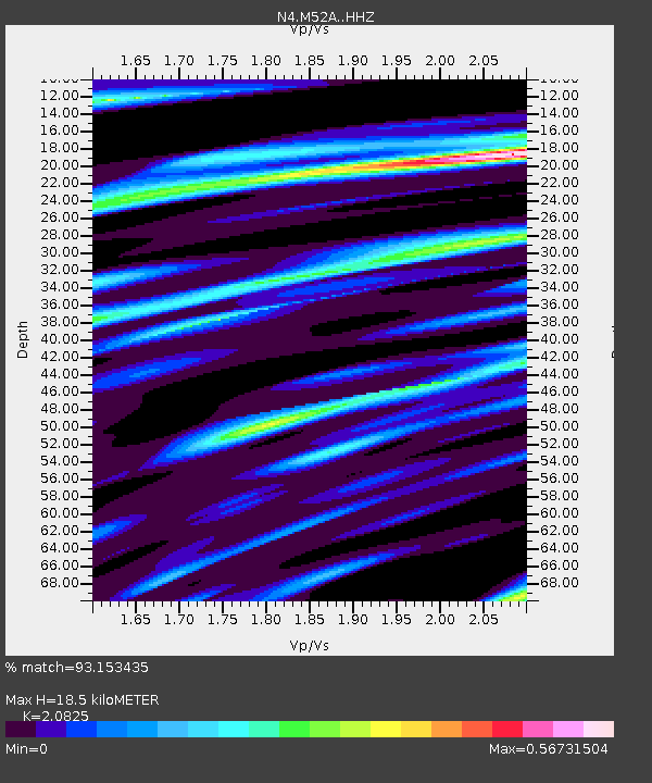
| Estimated Moho Depth: |
18.5 km |
| Estimated Crust Vp/Vs: |
2.08 |
| Assumed Crust Vp: |
6.483 km/s |
| Estimated Crust Vs: |
3.113 km/s |
| Estimated Crust Poisson's Ratio: |
0.35 |
|
| Radial Match: |
93.153435 % |
| Radial Bump: |
290 |
| Transverse Match: |
69.474464 % |
| Transverse Bump: |
400 |
| SOD ConfigId: |
13570011 |
| Insert Time: |
2019-05-01 23:17:40.428 +0000 |
| GWidth: |
2.5 |
| Max Bumps: |
400 |
| Tol: |
0.001 |
|

Signal To Noise
| Channel | StoN | STA | LTA |
| N4:M52A: :HHZ:20181130T17:37:07.220006Z | 15.310044 | 1.750876E-5 | 1.1436126E-6 |
| N4:M52A: :HHN:20181130T17:37:07.220006Z | 9.660221 | 7.6172682E-6 | 7.88519E-7 |
| N4:M52A: :HHE:20181130T17:37:07.220006Z | 7.4091454 | 7.5453395E-6 | 1.0183819E-6 |
| Arrivals |
| Ps | 3.3 SECOND |
| PpPs | 8.3 SECOND |
| PsPs/PpSs | 12 SECOND |


