You are here: Home > Network List > N4 - Central and EAstern US Network Stations List
> Station P61A Hammonton, NJ, USA > Earthquake Result Viewer
P61A Hammonton, NJ, USA - Earthquake Result Viewer
| Earthquake location: |
Southern Alaska |
| Earthquake latitude/longitude: |
61.3/-149.9 |
| Earthquake time(UTC): |
2018/11/30 (334) 17:29:28 GMT |
| Earthquake Depth: |
43 km |
| Earthquake Magnitude: |
6.6 ml |
| Earthquake Catalog/Contributor: |
NEIC PDE/ak |
|
| Network: |
N4 Central and EAstern US Network |
| Station: |
P61A Hammonton, NJ, USA |
| Lat/Lon: |
39.67 N/74.79 W |
| Elevation: |
22 m |
|
| Distance: |
49.3 deg |
| Az: |
79.875 deg |
| Baz: |
322.042 deg |
| Ray Param: |
0.06870986 |
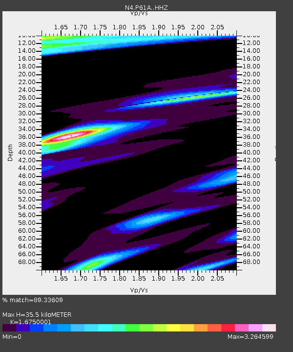
| Estimated Moho Depth: |
35.5 km |
| Estimated Crust Vp/Vs: |
1.68 |
| Assumed Crust Vp: |
6.287 km/s |
| Estimated Crust Vs: |
3.754 km/s |
| Estimated Crust Poisson's Ratio: |
0.22 |
|
| Radial Match: |
89.33609 % |
| Radial Bump: |
343 |
| Transverse Match: |
78.21214 % |
| Transverse Bump: |
400 |
| SOD ConfigId: |
13570011 |
| Insert Time: |
2019-05-01 23:17:56.849 +0000 |
| GWidth: |
2.5 |
| Max Bumps: |
400 |
| Tol: |
0.001 |
|

Signal To Noise
| Channel | StoN | STA | LTA |
| N4:P61A: :HHZ:20181130T17:37:42.919988Z | 49.23897 | 3.1595515E-5 | 6.41677E-7 |
| N4:P61A: :HHN:20181130T17:37:42.919988Z | 16.320131 | 2.140142E-5 | 1.311351E-6 |
| N4:P61A: :HHE:20181130T17:37:42.919988Z | 8.051214 | 1.5938069E-5 | 1.979586E-6 |
| Arrivals |
| Ps | 4.0 SECOND |
| PpPs | 14 SECOND |
| PsPs/PpSs | 18 SECOND |


