You are here: Home > Network List > TA - USArray Transportable Network (new EarthScope stations) Stations List
> Station I21A Big Trails, Ten Sleep, WY, USA > Earthquake Result Viewer
I21A Big Trails, Ten Sleep, WY, USA - Earthquake Result Viewer
| Earthquake location: |
North Of Severnaya Zemlya |
| Earthquake latitude/longitude: |
83.6/115.2 |
| Earthquake time(UTC): |
2008/08/13 (226) 08:35:02 GMT |
| Earthquake Depth: |
10 km |
| Earthquake Magnitude: |
5.5 MB, 4.7 MS, 5.4 MW, 5.4 MW |
| Earthquake Catalog/Contributor: |
WHDF/NEIC |
|
| Network: |
TA USArray Transportable Network (new EarthScope stations) |
| Station: |
I21A Big Trails, Ten Sleep, WY, USA |
| Lat/Lon: |
43.81 N/107.29 W |
| Elevation: |
1639 m |
|
| Distance: |
51.2 deg |
| Az: |
38.879 deg |
| Baz: |
354.453 deg |
| Ray Param: |
0.06753982 |
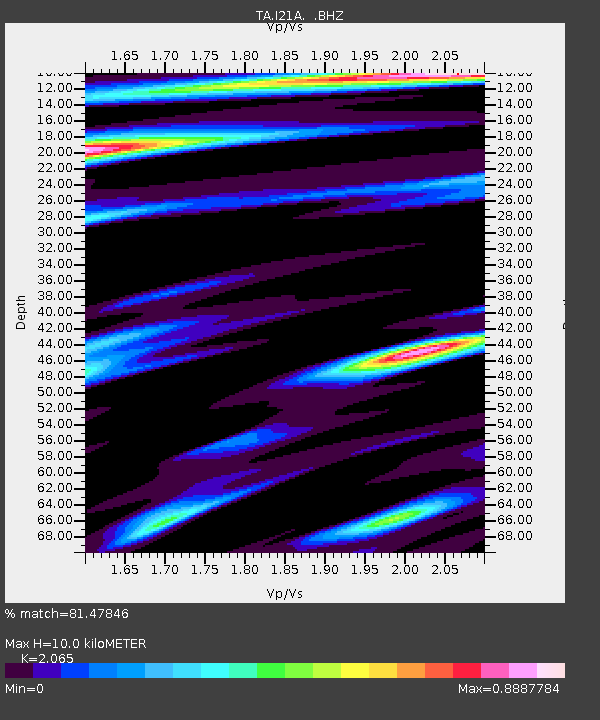
| Estimated Moho Depth: |
10.0 km |
| Estimated Crust Vp/Vs: |
2.07 |
| Assumed Crust Vp: |
6.178 km/s |
| Estimated Crust Vs: |
2.992 km/s |
| Estimated Crust Poisson's Ratio: |
0.35 |
|
| Radial Match: |
81.47846 % |
| Radial Bump: |
400 |
| Transverse Match: |
75.417694 % |
| Transverse Bump: |
400 |
| SOD ConfigId: |
2504 |
| Insert Time: |
2010-03-06 18:23:10.586 +0000 |
| GWidth: |
2.5 |
| Max Bumps: |
400 |
| Tol: |
0.001 |
|

Signal To Noise
| Channel | StoN | STA | LTA |
| TA:I21A: :BHZ:20080813T08:43:34.725027Z | 7.9722133 | 4.5214543E-7 | 5.671517E-8 |
| TA:I21A: :BHN:20080813T08:43:34.725027Z | 4.1438327 | 2.3571751E-7 | 5.6883934E-8 |
| TA:I21A: :BHE:20080813T08:43:34.725027Z | 2.843137 | 9.684679E-8 | 3.406336E-8 |
| Arrivals |
| Ps | 1.8 SECOND |
| PpPs | 4.7 SECOND |
| PsPs/PpSs | 6.5 SECOND |


