You are here: Home > Network List > N4 - Central and EAstern US Network Stations List
> Station TUL3 Leonard, OK, USA > Earthquake Result Viewer
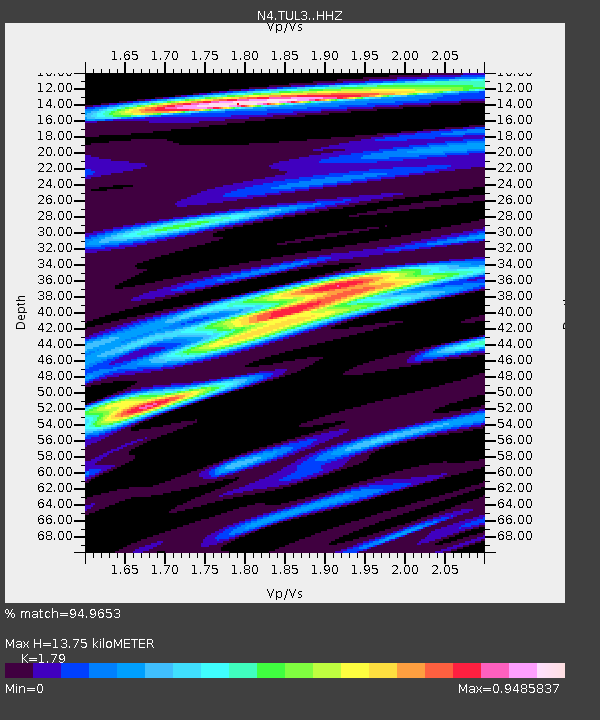
TUL3 Leonard, OK, USA - Earthquake Result Viewer
| Earthquake location: |
Southern Alaska |
| Earthquake latitude/longitude: |
61.3/-149.9 |
| Earthquake time(UTC): |
2018/11/30 (334) 17:29:28 GMT |
| Earthquake Depth: |
43 km |
| Earthquake Magnitude: |
6.6 ml |
| Earthquake Catalog/Contributor: |
NEIC PDE/ak |
|
| Network: |
N4 Central and EAstern US Network |
| Station: |
TUL3 Leonard, OK, USA |
| Lat/Lon: |
35.91 N/95.79 W |
| Elevation: |
265 m |
|
| Distance: |
42.2 deg |
| Az: |
101.599 deg |
| Baz: |
324.416 deg |
| Ray Param: |
0.073219374 |
| Estimated Moho Depth: |
13.75 km |
| Estimated Crust Vp/Vs: |
1.79 |
| Assumed Crust Vp: |
6.498 km/s |
| Estimated Crust Vs: |
3.63 km/s |
| Estimated Crust Poisson's Ratio: |
0.27 |
|
| Radial Match: |
94.9653 % |
| Radial Bump: |
343 |
| Transverse Match: |
78.02113 % |
| Transverse Bump: |
400 |
| SOD ConfigId: |
13570011 |
| Insert Time: |
2019-05-01 23:18:19.953 +0000 |
| GWidth: |
2.5 |
| Max Bumps: |
400 |
| Tol: |
0.001 |
|

Signal To Noise
| Channel | StoN | STA | LTA |
| N4:TUL3: :HHZ:20181130T17:36:47.239995Z | 26.08659 | 1.3230078E-5 | 5.071601E-7 |
| N4:TUL3: :HHN:20181130T17:36:47.239995Z | 10.190411 | 6.417027E-6 | 6.297123E-7 |
| N4:TUL3: :HHE:20181130T17:36:47.239995Z | 11.12235 | 5.473006E-6 | 4.9207284E-7 |
| Arrivals |
| Ps | 1.8 SECOND |
| PpPs | 5.5 SECOND |
| PsPs/PpSs | 7.3 SECOND |


