You are here: Home > Network List > N4 - Central and EAstern US Network Stations List
> Station V58A WIndy Hill, Pittsboro, NC, USA > Earthquake Result Viewer
V58A WIndy Hill, Pittsboro, NC, USA - Earthquake Result Viewer
| Earthquake location: |
Southern Alaska |
| Earthquake latitude/longitude: |
61.3/-149.9 |
| Earthquake time(UTC): |
2018/11/30 (334) 17:29:28 GMT |
| Earthquake Depth: |
43 km |
| Earthquake Magnitude: |
6.6 ml |
| Earthquake Catalog/Contributor: |
NEIC PDE/ak |
|
| Network: |
N4 Central and EAstern US Network |
| Station: |
V58A WIndy Hill, Pittsboro, NC, USA |
| Lat/Lon: |
35.79 N/79.11 W |
| Elevation: |
127 m |
|
| Distance: |
50.3 deg |
| Az: |
86.516 deg |
| Baz: |
323.696 deg |
| Ray Param: |
0.06805675 |
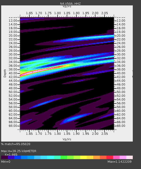
| Estimated Moho Depth: |
39.25 km |
| Estimated Crust Vp/Vs: |
1.66 |
| Assumed Crust Vp: |
6.565 km/s |
| Estimated Crust Vs: |
3.943 km/s |
| Estimated Crust Poisson's Ratio: |
0.22 |
|
| Radial Match: |
95.05828 % |
| Radial Bump: |
237 |
| Transverse Match: |
77.518364 % |
| Transverse Bump: |
400 |
| SOD ConfigId: |
13570011 |
| Insert Time: |
2019-05-01 23:18:28.860 +0000 |
| GWidth: |
2.5 |
| Max Bumps: |
400 |
| Tol: |
0.001 |
|

Signal To Noise
| Channel | StoN | STA | LTA |
| N4:V58A: :HHZ:20181130T17:37:50.660009Z | 68.41734 | 1.6016822E-5 | 2.341047E-7 |
| N4:V58A: :HHN:20181130T17:37:50.660009Z | 18.355309 | 8.156425E-6 | 4.4436328E-7 |
| N4:V58A: :HHE:20181130T17:37:50.660009Z | 22.35085 | 6.480429E-6 | 2.8994106E-7 |
| Arrivals |
| Ps | 4.2 SECOND |
| PpPs | 15 SECOND |
| PsPs/PpSs | 19 SECOND |


