You are here: Home > Network List > TA - USArray Transportable Network (new EarthScope stations) Stations List
> Station I21A Big Trails, Ten Sleep, WY, USA > Earthquake Result Viewer
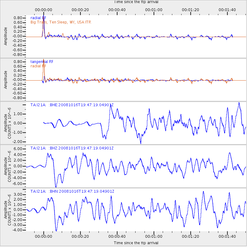
I21A Big Trails, Ten Sleep, WY, USA - Earthquake Result Viewer

| Earthquake location: |
Near Coast Of Chiapas, Mexico |
| Earthquake latitude/longitude: |
14.4/-92.4 |
| Earthquake time(UTC): |
2008/10/16 (290) 19:41:25 GMT |
| Earthquake Depth: |
24 km |
| Earthquake Magnitude: |
6.1 MB, 6.6 MS, 6.7 MW, 6.6 MW |
| Earthquake Catalog/Contributor: |
WHDF/NEIC |
|
| Network: |
TA USArray Transportable Network (new EarthScope stations) |
| Station: |
I21A Big Trails, Ten Sleep, WY, USA |
| Lat/Lon: |
43.81 N/107.29 W |
| Elevation: |
1639 m |
|
| Distance: |
32.0 deg |
| Az: |
339.367 deg |
| Baz: |
151.86 deg |
| Ray Param: |
0.0788292 |
| Estimated Moho Depth: |
50.5 km |
| Estimated Crust Vp/Vs: |
1.93 |
| Assumed Crust Vp: |
6.178 km/s |
| Estimated Crust Vs: |
3.201 km/s |
| Estimated Crust Poisson's Ratio: |
0.32 |
|
| Radial Match: |
93.98778 % |
| Radial Bump: |
303 |
| Transverse Match: |
70.21736 % |
| Transverse Bump: |
400 |
| SOD ConfigId: |
2556 |
| Insert Time: |
2010-03-06 18:23:21.022 +0000 |
| GWidth: |
2.5 |
| Max Bumps: |
400 |
| Tol: |
0.001 |
|
Signal To Noise
| Channel | StoN | STA | LTA |
| TA:I21A: :BHZ:20081016T19:47:19.04901Z | 21.832422 | 2.7068256E-6 | 1.2398192E-7 |
| TA:I21A: :BHN:20081016T19:47:19.04901Z | 8.8789835 | 1.5449402E-6 | 1.7399968E-7 |
| TA:I21A: :BHE:20081016T19:47:19.04901Z | 5.122349 | 9.583723E-7 | 1.8709625E-7 |
| Arrivals |
| Ps | 8.1 SECOND |
| PpPs | 22 SECOND |
| PsPs/PpSs | 31 SECOND |


