You are here: Home > Network List > N4 - Central and EAstern US Network Stations List
> Station Y45B Coffeeville, MS, USA > Earthquake Result Viewer
Y45B Coffeeville, MS, USA - Earthquake Result Viewer
| Earthquake location: |
Southern Alaska |
| Earthquake latitude/longitude: |
61.3/-149.9 |
| Earthquake time(UTC): |
2018/11/30 (334) 17:29:28 GMT |
| Earthquake Depth: |
43 km |
| Earthquake Magnitude: |
6.6 ml |
| Earthquake Catalog/Contributor: |
NEIC PDE/ak |
|
| Network: |
N4 Central and EAstern US Network |
| Station: |
Y45B Coffeeville, MS, USA |
| Lat/Lon: |
33.87 N/89.54 W |
| Elevation: |
101 m |
|
| Distance: |
46.8 deg |
| Az: |
97.304 deg |
| Baz: |
324.911 deg |
| Ray Param: |
0.07029013 |
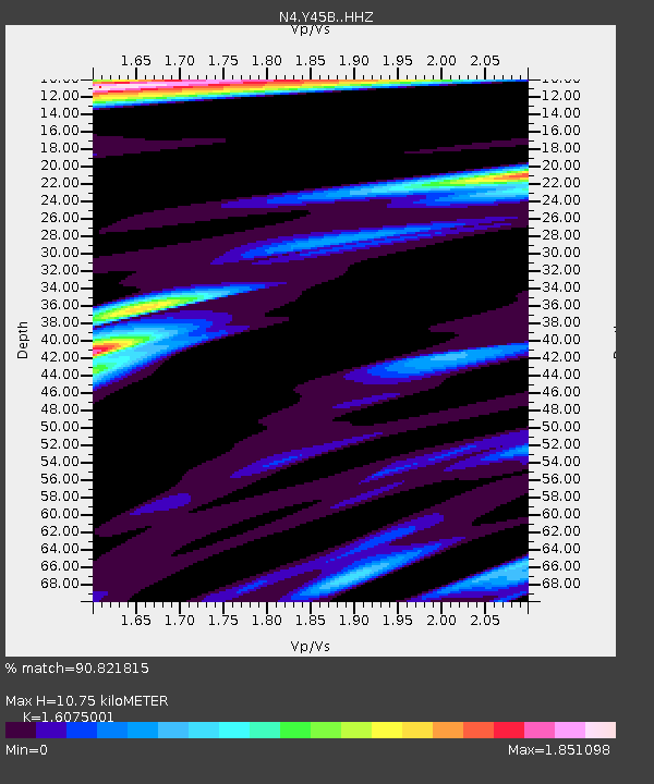
| Estimated Moho Depth: |
10.75 km |
| Estimated Crust Vp/Vs: |
1.61 |
| Assumed Crust Vp: |
6.201 km/s |
| Estimated Crust Vs: |
3.858 km/s |
| Estimated Crust Poisson's Ratio: |
0.18 |
|
| Radial Match: |
90.821815 % |
| Radial Bump: |
306 |
| Transverse Match: |
82.24926 % |
| Transverse Bump: |
400 |
| SOD ConfigId: |
13570011 |
| Insert Time: |
2019-05-01 23:18:35.379 +0000 |
| GWidth: |
2.5 |
| Max Bumps: |
400 |
| Tol: |
0.001 |
|

Signal To Noise
| Channel | StoN | STA | LTA |
| N4:Y45B: :HHZ:20181130T17:37:24.149999Z | 27.815582 | 2.677282E-5 | 9.625115E-7 |
| N4:Y45B: :HHN:20181130T17:37:24.149999Z | 6.246735 | 1.6386746E-5 | 2.6232499E-6 |
| N4:Y45B: :HHE:20181130T17:37:24.149999Z | 12.4527 | 8.940372E-6 | 7.179465E-7 |
| Arrivals |
| Ps | 1.1 SECOND |
| PpPs | 4.2 SECOND |
| PsPs/PpSs | 5.4 SECOND |


