You are here: Home > Network List > O2 - Oklahoma Consolidated Temporary Seismic Networks Stations List
> Station DRUM Drumwright, Oklahoma, USA > Earthquake Result Viewer
DRUM Drumwright, Oklahoma, USA - Earthquake Result Viewer
| Earthquake location: |
Southern Alaska |
| Earthquake latitude/longitude: |
61.3/-149.9 |
| Earthquake time(UTC): |
2018/11/30 (334) 17:29:28 GMT |
| Earthquake Depth: |
43 km |
| Earthquake Magnitude: |
6.6 ml |
| Earthquake Catalog/Contributor: |
NEIC PDE/ak |
|
| Network: |
O2 Oklahoma Consolidated Temporary Seismic Networks |
| Station: |
DRUM Drumwright, Oklahoma, USA |
| Lat/Lon: |
35.92 N/96.61 W |
| Elevation: |
296 m |
|
| Distance: |
41.8 deg |
| Az: |
102.395 deg |
| Baz: |
324.532 deg |
| Ray Param: |
0.07345348 |
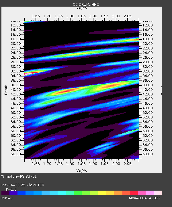
| Estimated Moho Depth: |
33.25 km |
| Estimated Crust Vp/Vs: |
1.60 |
| Assumed Crust Vp: |
6.426 km/s |
| Estimated Crust Vs: |
4.016 km/s |
| Estimated Crust Poisson's Ratio: |
0.18 |
|
| Radial Match: |
93.33701 % |
| Radial Bump: |
319 |
| Transverse Match: |
74.62881 % |
| Transverse Bump: |
400 |
| SOD ConfigId: |
13570011 |
| Insert Time: |
2019-05-01 23:19:24.480 +0000 |
| GWidth: |
2.5 |
| Max Bumps: |
400 |
| Tol: |
0.001 |
|

Signal To Noise
| Channel | StoN | STA | LTA |
| O2:DRUM: :HHZ:20181130T17:36:44.064Z | 30.779634 | 1.2929291E-5 | 4.2005993E-7 |
| O2:DRUM: :HH1:20181130T17:36:44.064Z | 10.295892 | 5.3272124E-6 | 5.174115E-7 |
| O2:DRUM: :HH2:20181130T17:36:44.064Z | 6.9790807 | 5.802414E-6 | 8.314009E-7 |
| Arrivals |
| Ps | 3.3 SECOND |
| PpPs | 12 SECOND |
| PsPs/PpSs | 16 SECOND |


