You are here: Home > Network List > OH - Ohio Seismic Network Stations List
> Station SSFO Shawnee State Forest Ohio > Earthquake Result Viewer
SSFO Shawnee State Forest Ohio - Earthquake Result Viewer
| Earthquake location: |
Southern Alaska |
| Earthquake latitude/longitude: |
61.3/-149.9 |
| Earthquake time(UTC): |
2018/11/30 (334) 17:29:28 GMT |
| Earthquake Depth: |
43 km |
| Earthquake Magnitude: |
6.6 ml |
| Earthquake Catalog/Contributor: |
NEIC PDE/ak |
|
| Network: |
OH Ohio Seismic Network |
| Station: |
SSFO Shawnee State Forest Ohio |
| Lat/Lon: |
38.70 N/83.20 W |
| Elevation: |
365 m |
|
| Distance: |
46.0 deg |
| Az: |
87.655 deg |
| Baz: |
321.995 deg |
| Ray Param: |
0.0708087 |
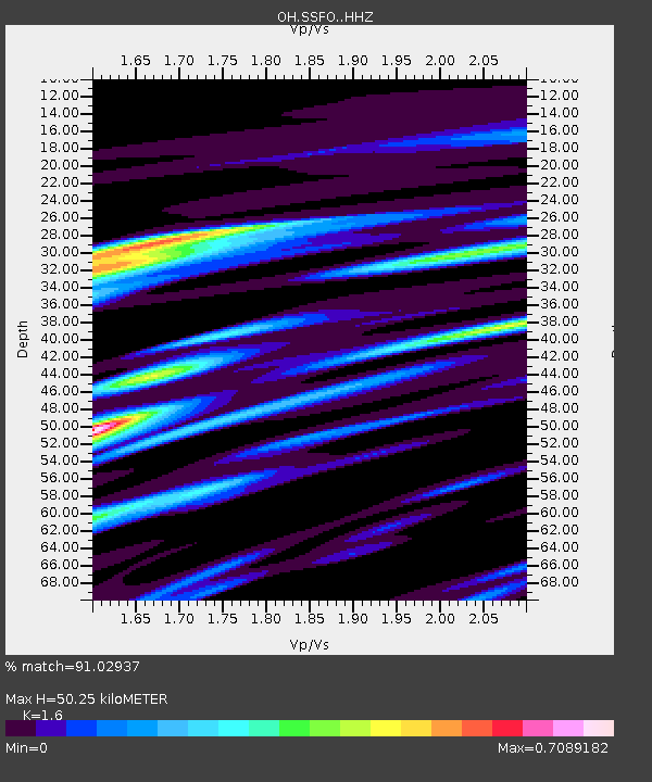
| Estimated Moho Depth: |
50.25 km |
| Estimated Crust Vp/Vs: |
1.60 |
| Assumed Crust Vp: |
6.232 km/s |
| Estimated Crust Vs: |
3.895 km/s |
| Estimated Crust Poisson's Ratio: |
0.18 |
|
| Radial Match: |
91.02937 % |
| Radial Bump: |
292 |
| Transverse Match: |
69.86987 % |
| Transverse Bump: |
400 |
| SOD ConfigId: |
13570011 |
| Insert Time: |
2019-05-01 23:19:33.772 +0000 |
| GWidth: |
2.5 |
| Max Bumps: |
400 |
| Tol: |
0.001 |
|

Signal To Noise
| Channel | StoN | STA | LTA |
| OH:SSFO: :HHZ:20181130T17:37:17.739995Z | 19.704697 | 1.8768424E-5 | 9.5248475E-7 |
| OH:SSFO: :HHN:20181130T17:37:17.739995Z | 9.569603 | 8.287589E-6 | 8.660327E-7 |
| OH:SSFO: :HHE:20181130T17:37:17.739995Z | 11.990745 | 7.629734E-6 | 6.3630193E-7 |
| Arrivals |
| Ps | 5.2 SECOND |
| PpPs | 20 SECOND |
| PsPs/PpSs | 25 SECOND |


