You are here: Home > Network List > OK - Oklahoma Seismic Network Stations List
> Station BLOK Blackwell, Oklahoma, USA > Earthquake Result Viewer
BLOK Blackwell, Oklahoma, USA - Earthquake Result Viewer
| Earthquake location: |
Southern Alaska |
| Earthquake latitude/longitude: |
61.3/-149.9 |
| Earthquake time(UTC): |
2018/11/30 (334) 17:29:28 GMT |
| Earthquake Depth: |
43 km |
| Earthquake Magnitude: |
6.6 ml |
| Earthquake Catalog/Contributor: |
NEIC PDE/ak |
|
| Network: |
OK Oklahoma Seismic Network |
| Station: |
BLOK Blackwell, Oklahoma, USA |
| Lat/Lon: |
36.76 N/97.22 W |
| Elevation: |
301 m |
|
| Distance: |
40.8 deg |
| Az: |
102.258 deg |
| Baz: |
324.07 deg |
| Ray Param: |
0.07406342 |
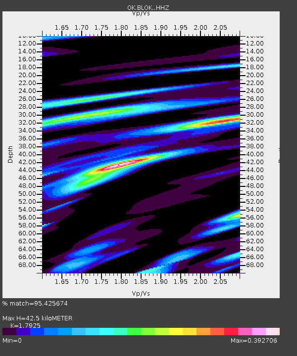
| Estimated Moho Depth: |
42.5 km |
| Estimated Crust Vp/Vs: |
1.79 |
| Assumed Crust Vp: |
6.483 km/s |
| Estimated Crust Vs: |
3.617 km/s |
| Estimated Crust Poisson's Ratio: |
0.27 |
|
| Radial Match: |
95.425674 % |
| Radial Bump: |
363 |
| Transverse Match: |
95.44255 % |
| Transverse Bump: |
346 |
| SOD ConfigId: |
13570011 |
| Insert Time: |
2019-05-01 23:19:35.287 +0000 |
| GWidth: |
2.5 |
| Max Bumps: |
400 |
| Tol: |
0.001 |
|

Signal To Noise
| Channel | StoN | STA | LTA |
| OK:BLOK: :HHZ:20181130T17:36:36.129003Z | 40.947678 | 1.8832954E-5 | 4.599273E-7 |
| OK:BLOK: :HHN:20181130T17:36:36.129003Z | 0.9036167 | 6.595605E-8 | 7.2991185E-8 |
| OK:BLOK: :HHE:20181130T17:36:36.129003Z | 10.195377 | 7.875898E-6 | 7.7249695E-7 |
| Arrivals |
| Ps | 5.6 SECOND |
| PpPs | 17 SECOND |
| PsPs/PpSs | 23 SECOND |


