You are here: Home > Network List > TA - USArray Transportable Network (new EarthScope stations) Stations List
> Station I21A Big Trails, Ten Sleep, WY, USA > Earthquake Result Viewer
I21A Big Trails, Ten Sleep, WY, USA - Earthquake Result Viewer
| Earthquake location: |
Santa Cruz Islands |
| Earthquake latitude/longitude: |
-11.6/166.1 |
| Earthquake time(UTC): |
2009/08/10 (222) 04:06:31 GMT |
| Earthquake Depth: |
35 km |
| Earthquake Magnitude: |
5.8 MB, 6.3 MS, 6.6 MW, 6.6 MW |
| Earthquake Catalog/Contributor: |
WHDF/NEIC |
|
| Network: |
TA USArray Transportable Network (new EarthScope stations) |
| Station: |
I21A Big Trails, Ten Sleep, WY, USA |
| Lat/Lon: |
43.81 N/107.29 W |
| Elevation: |
1639 m |
|
| Distance: |
95.5 deg |
| Az: |
46.555 deg |
| Baz: |
259.309 deg |
| Ray Param: |
0.040745866 |
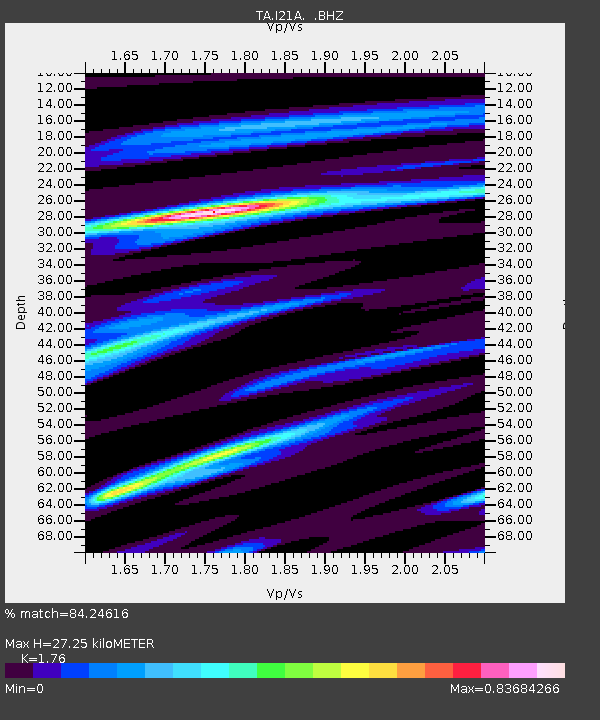
| Estimated Moho Depth: |
27.25 km |
| Estimated Crust Vp/Vs: |
1.76 |
| Assumed Crust Vp: |
6.178 km/s |
| Estimated Crust Vs: |
3.51 km/s |
| Estimated Crust Poisson's Ratio: |
0.26 |
|
| Radial Match: |
84.24616 % |
| Radial Bump: |
400 |
| Transverse Match: |
61.266678 % |
| Transverse Bump: |
400 |
| SOD ConfigId: |
2622 |
| Insert Time: |
2010-03-06 18:23:40.975 +0000 |
| GWidth: |
2.5 |
| Max Bumps: |
400 |
| Tol: |
0.001 |
|

Signal To Noise
| Channel | StoN | STA | LTA |
| TA:I21A: :BHZ:20090810T04:19:20.924011Z | 9.900617 | 4.3747949E-7 | 4.4187097E-8 |
| TA:I21A: :BHN:20090810T04:19:20.924011Z | 0.9011734 | 3.7210587E-8 | 4.1291262E-8 |
| TA:I21A: :BHE:20090810T04:19:20.924011Z | 6.209238 | 1.6278098E-7 | 2.6215934E-8 |
| Arrivals |
| Ps | 3.4 SECOND |
| PpPs | 12 SECOND |
| PsPs/PpSs | 15 SECOND |


