You are here: Home > Network List > PE - Penn State Network Stations List
> Station PACH Chapman State Park, Clarendon, PA > Earthquake Result Viewer
PACH Chapman State Park, Clarendon, PA - Earthquake Result Viewer
| Earthquake location: |
Southern Alaska |
| Earthquake latitude/longitude: |
61.3/-149.9 |
| Earthquake time(UTC): |
2018/11/30 (334) 17:29:28 GMT |
| Earthquake Depth: |
43 km |
| Earthquake Magnitude: |
6.6 ml |
| Earthquake Catalog/Contributor: |
NEIC PDE/ak |
|
| Network: |
PE Penn State Network |
| Station: |
PACH Chapman State Park, Clarendon, PA |
| Lat/Lon: |
41.76 N/79.17 W |
| Elevation: |
431 m |
|
| Distance: |
45.6 deg |
| Az: |
81.63 deg |
| Baz: |
320.383 deg |
| Ray Param: |
0.07108984 |
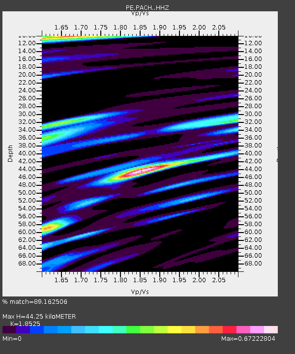
| Estimated Moho Depth: |
44.25 km |
| Estimated Crust Vp/Vs: |
1.85 |
| Assumed Crust Vp: |
6.121 km/s |
| Estimated Crust Vs: |
3.304 km/s |
| Estimated Crust Poisson's Ratio: |
0.29 |
|
| Radial Match: |
89.162506 % |
| Radial Bump: |
322 |
| Transverse Match: |
64.637856 % |
| Transverse Bump: |
400 |
| SOD ConfigId: |
13570011 |
| Insert Time: |
2019-05-01 23:20:09.207 +0000 |
| GWidth: |
2.5 |
| Max Bumps: |
400 |
| Tol: |
0.001 |
|

Signal To Noise
| Channel | StoN | STA | LTA |
| PE:PACH: :HHZ:20181130T17:37:14.185002Z | 15.939954 | 1.9839668E-5 | 1.2446503E-6 |
| PE:PACH: :HHN:20181130T17:37:14.185002Z | 5.694611 | 9.743619E-6 | 1.7110244E-6 |
| PE:PACH: :HHE:20181130T17:37:14.185002Z | 9.3619175 | 6.949838E-6 | 7.42352E-7 |
| Arrivals |
| Ps | 6.5 SECOND |
| PpPs | 20 SECOND |
| PsPs/PpSs | 26 SECOND |


