You are here: Home > Network List > TA - USArray Transportable Network (new EarthScope stations) Stations List
> Station I21A Big Trails, Ten Sleep, WY, USA > Earthquake Result Viewer
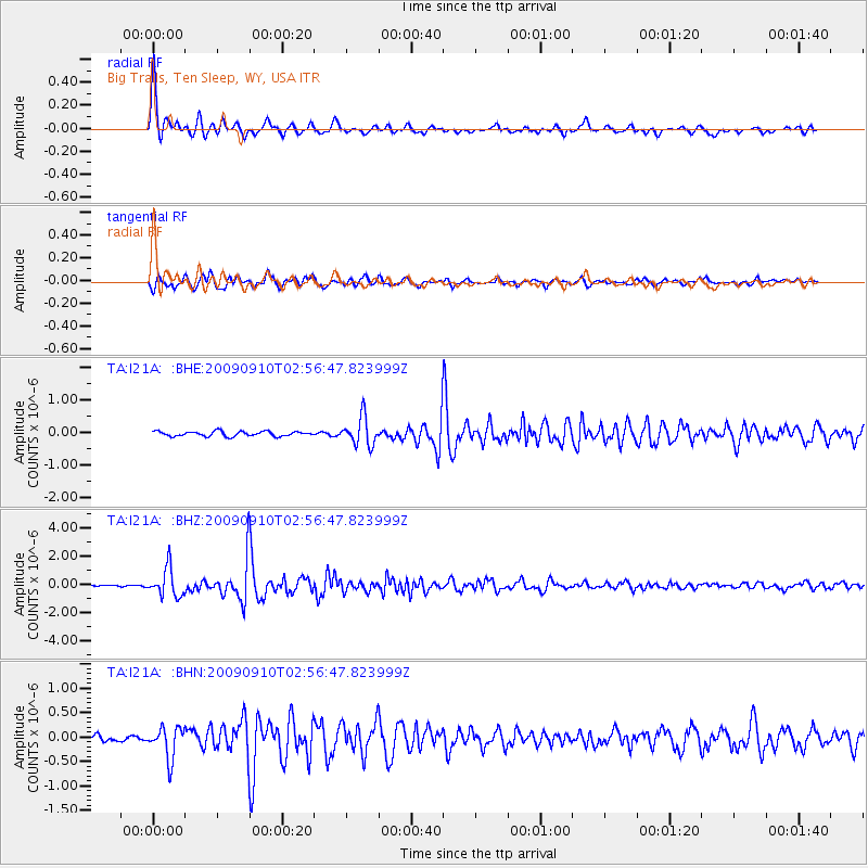
I21A Big Trails, Ten Sleep, WY, USA - Earthquake Result Viewer

| Earthquake location: |
Kuril Islands |
| Earthquake latitude/longitude: |
48.3/154.2 |
| Earthquake time(UTC): |
2009/09/10 (253) 02:46:50 GMT |
| Earthquake Depth: |
36 km |
| Earthquake Magnitude: |
6.0 MB, 5.5 MS, 6.0 MW, 5.8 MW |
| Earthquake Catalog/Contributor: |
WHDF/NEIC |
|
| Network: |
TA USArray Transportable Network (new EarthScope stations) |
| Station: |
I21A Big Trails, Ten Sleep, WY, USA |
| Lat/Lon: |
43.81 N/107.29 W |
| Elevation: |
1639 m |
|
| Distance: |
63.8 deg |
| Az: |
52.959 deg |
| Baz: |
312.61 deg |
| Ray Param: |
0.059304394 |
| Estimated Moho Depth: |
69.75 km |
| Estimated Crust Vp/Vs: |
1.62 |
| Assumed Crust Vp: |
6.178 km/s |
| Estimated Crust Vs: |
3.814 km/s |
| Estimated Crust Poisson's Ratio: |
0.19 |
|
| Radial Match: |
94.254 % |
| Radial Bump: |
335 |
| Transverse Match: |
83.779884 % |
| Transverse Bump: |
400 |
| SOD ConfigId: |
2622 |
| Insert Time: |
2010-03-06 18:23:51.178 +0000 |
| GWidth: |
2.5 |
| Max Bumps: |
400 |
| Tol: |
0.001 |
|
Signal To Noise
| Channel | StoN | STA | LTA |
| TA:I21A: :BHZ:20090910T02:56:47.823999Z | 9.339664 | 1.0017164E-6 | 1.0725401E-7 |
| TA:I21A: :BHN:20090910T02:56:47.823999Z | 4.305967 | 3.2035925E-7 | 7.439891E-8 |
| TA:I21A: :BHE:20090910T02:56:47.823999Z | 5.7787137 | 4.286595E-7 | 7.417905E-8 |
| Arrivals |
| Ps | 7.3 SECOND |
| PpPs | 28 SECOND |
| PsPs/PpSs | 36 SECOND |


