You are here: Home > Network List > PE - Penn State Network Stations List
> Station PAMP Mt. Pisgah State Park, Troy, PA > Earthquake Result Viewer
PAMP Mt. Pisgah State Park, Troy, PA - Earthquake Result Viewer
| Earthquake location: |
Southern Alaska |
| Earthquake latitude/longitude: |
61.3/-149.9 |
| Earthquake time(UTC): |
2018/11/30 (334) 17:29:28 GMT |
| Earthquake Depth: |
43 km |
| Earthquake Magnitude: |
6.6 ml |
| Earthquake Catalog/Contributor: |
NEIC PDE/ak |
|
| Network: |
PE Penn State Network |
| Station: |
PAMP Mt. Pisgah State Park, Troy, PA |
| Lat/Lon: |
41.81 N/76.67 W |
| Elevation: |
348 m |
|
| Distance: |
46.7 deg |
| Az: |
79.583 deg |
| Baz: |
320.626 deg |
| Ray Param: |
0.070365764 |
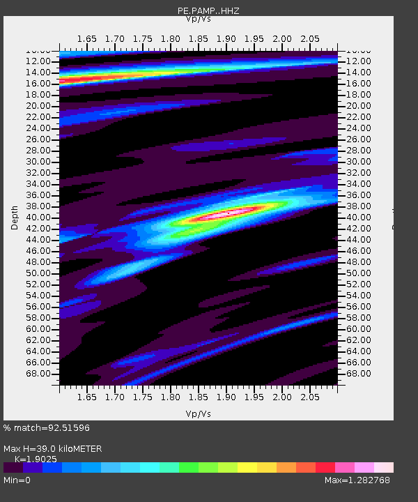
| Estimated Moho Depth: |
39.0 km |
| Estimated Crust Vp/Vs: |
1.90 |
| Assumed Crust Vp: |
6.121 km/s |
| Estimated Crust Vs: |
3.217 km/s |
| Estimated Crust Poisson's Ratio: |
0.31 |
|
| Radial Match: |
92.51596 % |
| Radial Bump: |
335 |
| Transverse Match: |
71.42613 % |
| Transverse Bump: |
400 |
| SOD ConfigId: |
13570011 |
| Insert Time: |
2019-05-01 23:20:14.208 +0000 |
| GWidth: |
2.5 |
| Max Bumps: |
400 |
| Tol: |
0.001 |
|

Signal To Noise
| Channel | StoN | STA | LTA |
| PE:PAMP: :HHZ:20181130T17:37:23.225011Z | 10.279024 | 2.0640478E-5 | 2.0080192E-6 |
| PE:PAMP: :HHN:20181130T17:37:23.225011Z | 7.6124754 | 7.5372564E-6 | 9.90119E-7 |
| PE:PAMP: :HHE:20181130T17:37:23.225011Z | 5.1714177 | 7.706237E-6 | 1.4901595E-6 |
| Arrivals |
| Ps | 6.1 SECOND |
| PpPs | 18 SECOND |
| PsPs/PpSs | 24 SECOND |


