You are here: Home > Network List > PS - Pacific21 Stations List
> Station PATS 6onpei, Micronesia > Earthquake Result Viewer
PATS 6onpei, Micronesia - Earthquake Result Viewer

| Earthquake location: |
Southern Alaska |
| Earthquake latitude/longitude: |
61.3/-149.9 |
| Earthquake time(UTC): |
2018/11/30 (334) 17:29:28 GMT |
| Earthquake Depth: |
43 km |
| Earthquake Magnitude: |
6.6 ml |
| Earthquake Catalog/Contributor: |
NEIC PDE/ak |
|
| Network: |
PS Pacific21 |
| Station: |
PATS 6onpei, Micronesia |
| Lat/Lon: |
6.84 N/158.32 E |
| Elevation: |
10 m |
|
| Distance: |
66.4 deg |
| Az: |
238.31 deg |
| Baz: |
24.408 deg |
| Ray Param: |
0.057545725 |
| Estimated Moho Depth: |
63.75 km |
| Estimated Crust Vp/Vs: |
1.88 |
| Assumed Crust Vp: |
4.24 km/s |
| Estimated Crust Vs: |
2.255 km/s |
| Estimated Crust Poisson's Ratio: |
0.30 |
|
| Radial Match: |
88.906586 % |
| Radial Bump: |
400 |
| Transverse Match: |
88.61763 % |
| Transverse Bump: |
400 |
| SOD ConfigId: |
13570011 |
| Insert Time: |
2019-05-01 23:20:44.012 +0000 |
| GWidth: |
2.5 |
| Max Bumps: |
400 |
| Tol: |
0.001 |
|
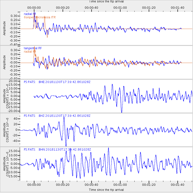
Signal To Noise
| Channel | StoN | STA | LTA |
| PS:PATS: :BHZ:20181130T17:39:42.861028Z | 9.616686 | 1.1264574E-5 | 1.1713571E-6 |
| PS:PATS: :BHN:20181130T17:39:42.861028Z | 2.9999557 | 3.7464258E-6 | 1.2488271E-6 |
| PS:PATS: :BHE:20181130T17:39:42.861028Z | 1.6104738 | 2.1608134E-6 | 1.3417254E-6 |
| Arrivals |
| Ps | 13 SECOND |
| PpPs | 43 SECOND |
| PsPs/PpSs | 56 SECOND |


