You are here: Home > Network List > PY - PFO Array Stations List
> Station BPH09 Pinon Flat Observatory, CA, USA > Earthquake Result Viewer
BPH09 Pinon Flat Observatory, CA, USA - Earthquake Result Viewer
| Earthquake location: |
Southern Alaska |
| Earthquake latitude/longitude: |
61.3/-149.9 |
| Earthquake time(UTC): |
2018/11/30 (334) 17:29:28 GMT |
| Earthquake Depth: |
43 km |
| Earthquake Magnitude: |
6.6 ml |
| Earthquake Catalog/Contributor: |
NEIC PDE/ak |
|
| Network: |
PY PFO Array |
| Station: |
BPH09 Pinon Flat Observatory, CA, USA |
| Lat/Lon: |
33.61 N/116.46 W |
| Elevation: |
1295 m |
|
| Distance: |
35.1 deg |
| Az: |
126.787 deg |
| Baz: |
332.433 deg |
| Ray Param: |
0.077318214 |
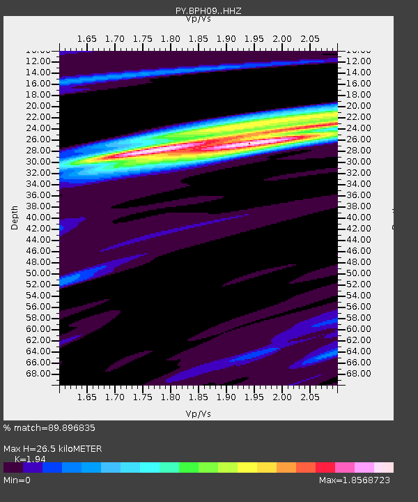
| Estimated Moho Depth: |
26.5 km |
| Estimated Crust Vp/Vs: |
1.94 |
| Assumed Crust Vp: |
6.264 km/s |
| Estimated Crust Vs: |
3.229 km/s |
| Estimated Crust Poisson's Ratio: |
0.32 |
|
| Radial Match: |
89.896835 % |
| Radial Bump: |
301 |
| Transverse Match: |
75.78739 % |
| Transverse Bump: |
400 |
| SOD ConfigId: |
13570011 |
| Insert Time: |
2019-05-01 23:21:01.039 +0000 |
| GWidth: |
2.5 |
| Max Bumps: |
400 |
| Tol: |
0.001 |
|

Signal To Noise
| Channel | StoN | STA | LTA |
| PY:BPH09: :HHZ:20181130T17:35:47.75501Z | 15.869997 | 9.737521E-6 | 6.135806E-7 |
| PY:BPH09: :HHN:20181130T17:35:47.75501Z | 11.055574 | 6.4514848E-6 | 5.835504E-7 |
| PY:BPH09: :HHE:20181130T17:35:47.75501Z | 4.8022823 | 2.140684E-6 | 4.4576387E-7 |
| Arrivals |
| Ps | 4.2 SECOND |
| PpPs | 12 SECOND |
| PsPs/PpSs | 16 SECOND |


