You are here: Home > Network List > TA - USArray Transportable Network (new EarthScope stations) Stations List
> Station I21A Big Trails, Ten Sleep, WY, USA > Earthquake Result Viewer
I21A Big Trails, Ten Sleep, WY, USA - Earthquake Result Viewer
| Earthquake location: |
Sea Of Okhotsk |
| Earthquake latitude/longitude: |
54.2/154.3 |
| Earthquake time(UTC): |
2008/11/24 (329) 09:02:58 GMT |
| Earthquake Depth: |
492 km |
| Earthquake Magnitude: |
6.5 MB, 7.3 MW, 7.3 MW |
| Earthquake Catalog/Contributor: |
WHDF/NEIC |
|
| Network: |
TA USArray Transportable Network (new EarthScope stations) |
| Station: |
I21A Big Trails, Ten Sleep, WY, USA |
| Lat/Lon: |
43.81 N/107.29 W |
| Elevation: |
1639 m |
|
| Distance: |
60.2 deg |
| Az: |
55.581 deg |
| Baz: |
317.975 deg |
| Ray Param: |
0.05979634 |
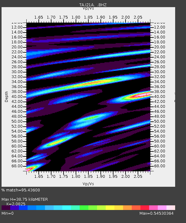
| Estimated Moho Depth: |
38.75 km |
| Estimated Crust Vp/Vs: |
2.08 |
| Assumed Crust Vp: |
6.178 km/s |
| Estimated Crust Vs: |
2.967 km/s |
| Estimated Crust Poisson's Ratio: |
0.35 |
|
| Radial Match: |
95.43608 % |
| Radial Bump: |
267 |
| Transverse Match: |
88.02121 % |
| Transverse Bump: |
400 |
| SOD ConfigId: |
2658 |
| Insert Time: |
2010-03-06 18:24:13.603 +0000 |
| GWidth: |
2.5 |
| Max Bumps: |
400 |
| Tol: |
0.001 |
|

Signal To Noise
| Channel | StoN | STA | LTA |
| TA:I21A: :BHZ:20081124T09:11:47.900015Z | 19.548603 | 4.039083E-6 | 2.0661746E-7 |
| TA:I21A: :BHN:20081124T09:11:47.900015Z | 4.49209 | 1.2916552E-6 | 2.8753988E-7 |
| TA:I21A: :BHE:20081124T09:11:47.900015Z | 4.844828 | 1.6241183E-6 | 3.352272E-7 |
| Arrivals |
| Ps | 7.0 SECOND |
| PpPs | 19 SECOND |
| PsPs/PpSs | 26 SECOND |


