You are here: Home > Network List > TA - USArray Transportable Network (new EarthScope stations) Stations List
> Station I21A Big Trails, Ten Sleep, WY, USA > Earthquake Result Viewer
I21A Big Trails, Ten Sleep, WY, USA - Earthquake Result Viewer
| Earthquake location: |
North Of Svalbard |
| Earthquake latitude/longitude: |
80.3/-1.9 |
| Earthquake time(UTC): |
2009/03/06 (065) 10:50:29 GMT |
| Earthquake Depth: |
9.0 km |
| Earthquake Magnitude: |
6.6 MB, 6.5 MS, 6.5 MW, 6.4 MW |
| Earthquake Catalog/Contributor: |
WHDF/NEIC |
|
| Network: |
TA USArray Transportable Network (new EarthScope stations) |
| Station: |
I21A Big Trails, Ten Sleep, WY, USA |
| Lat/Lon: |
43.81 N/107.29 W |
| Elevation: |
1639 m |
|
| Distance: |
49.7 deg |
| Az: |
293.723 deg |
| Baz: |
12.354 deg |
| Ray Param: |
0.06856184 |
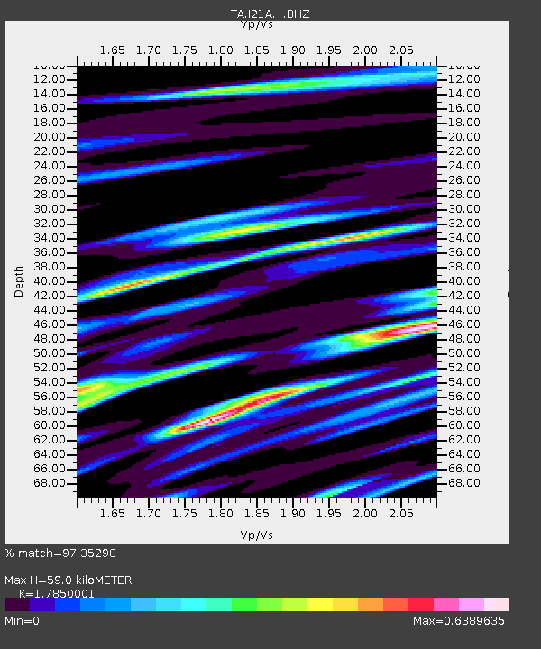
| Estimated Moho Depth: |
59.0 km |
| Estimated Crust Vp/Vs: |
1.79 |
| Assumed Crust Vp: |
6.178 km/s |
| Estimated Crust Vs: |
3.461 km/s |
| Estimated Crust Poisson's Ratio: |
0.27 |
|
| Radial Match: |
97.35298 % |
| Radial Bump: |
375 |
| Transverse Match: |
89.26059 % |
| Transverse Bump: |
400 |
| SOD ConfigId: |
2658 |
| Insert Time: |
2010-03-06 18:24:18.740 +0000 |
| GWidth: |
2.5 |
| Max Bumps: |
400 |
| Tol: |
0.001 |
|
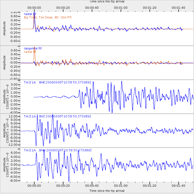
Signal To Noise
| Channel | StoN | STA | LTA |
| TA:I21A: :BHZ:20090306T10:58:50.373989Z | 40.53748 | 6.2657045E-6 | 1.5456573E-7 |
| TA:I21A: :BHN:20090306T10:58:50.373989Z | 16.173252 | 3.750898E-6 | 2.3191986E-7 |
| TA:I21A: :BHE:20090306T10:58:50.373989Z | 9.690341 | 1.1964479E-6 | 1.2346808E-7 |
| Arrivals |
| Ps | 7.9 SECOND |
| PpPs | 25 SECOND |
| PsPs/PpSs | 33 SECOND |


