You are here: Home > Network List > TA - USArray Transportable Network (new EarthScope stations) Stations List
> Station 121A Cookes Peak, Deming, NM, USA > Earthquake Result Viewer
121A Cookes Peak, Deming, NM, USA - Earthquake Result Viewer
| Earthquake location: |
Southern Alaska |
| Earthquake latitude/longitude: |
61.3/-149.9 |
| Earthquake time(UTC): |
2018/11/30 (334) 17:29:28 GMT |
| Earthquake Depth: |
43 km |
| Earthquake Magnitude: |
6.6 ml |
| Earthquake Catalog/Contributor: |
NEIC PDE/ak |
|
| Network: |
TA USArray Transportable Network (new EarthScope stations) |
| Station: |
121A Cookes Peak, Deming, NM, USA |
| Lat/Lon: |
32.53 N/107.79 W |
| Elevation: |
1652 m |
|
| Distance: |
39.6 deg |
| Az: |
117.143 deg |
| Baz: |
329.469 deg |
| Ray Param: |
0.07481075 |
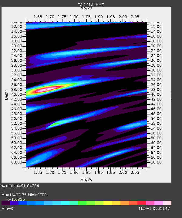
| Estimated Moho Depth: |
37.75 km |
| Estimated Crust Vp/Vs: |
1.68 |
| Assumed Crust Vp: |
6.502 km/s |
| Estimated Crust Vs: |
3.864 km/s |
| Estimated Crust Poisson's Ratio: |
0.23 |
|
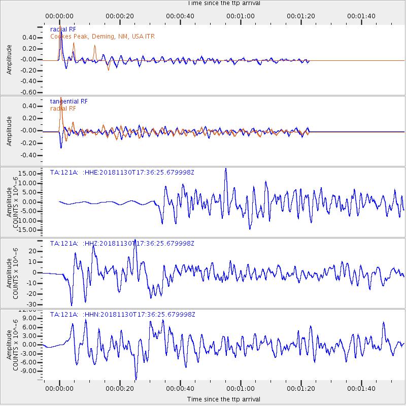
| Radial Match: |
91.84284 % |
| Radial Bump: |
400 |
| Transverse Match: |
77.12676 % |
| Transverse Bump: |
400 |
| SOD ConfigId: |
13570011 |
| Insert Time: |
2019-05-01 23:21:44.494 +0000 |
| GWidth: |
2.5 |
| Max Bumps: |
400 |
| Tol: |
0.001 |
|
Signal To Noise
| Channel | StoN | STA | LTA |
| TA:121A: :HHZ:20181130T17:36:25.679998Z | 26.846558 | 1.0650712E-5 | 3.9672543E-7 |
| TA:121A: :HHN:20181130T17:36:25.679998Z | 11.169689 | 2.9167354E-6 | 2.6112951E-7 |
| TA:121A: :HHE:20181130T17:36:25.679998Z | 7.180145 | 3.8206317E-6 | 5.321107E-7 |
| Arrivals |
| Ps | 4.3 SECOND |
| PpPs | 14 SECOND |
| PsPs/PpSs | 19 SECOND |


