You are here: Home > Network List > TA - USArray Transportable Network (new EarthScope stations) Stations List
> Station 833A Chaparral WMA, Artesia Wells, TX, USA > Earthquake Result Viewer
833A Chaparral WMA, Artesia Wells, TX, USA - Earthquake Result Viewer
| Earthquake location: |
Southern Alaska |
| Earthquake latitude/longitude: |
61.3/-149.9 |
| Earthquake time(UTC): |
2018/11/30 (334) 17:29:28 GMT |
| Earthquake Depth: |
43 km |
| Earthquake Magnitude: |
6.6 ml |
| Earthquake Catalog/Contributor: |
NEIC PDE/ak |
|
| Network: |
TA USArray Transportable Network (new EarthScope stations) |
| Station: |
833A Chaparral WMA, Artesia Wells, TX, USA |
| Lat/Lon: |
28.32 N/99.39 W |
| Elevation: |
171 m |
|
| Distance: |
46.9 deg |
| Az: |
111.148 deg |
| Baz: |
329.326 deg |
| Ray Param: |
0.07026435 |
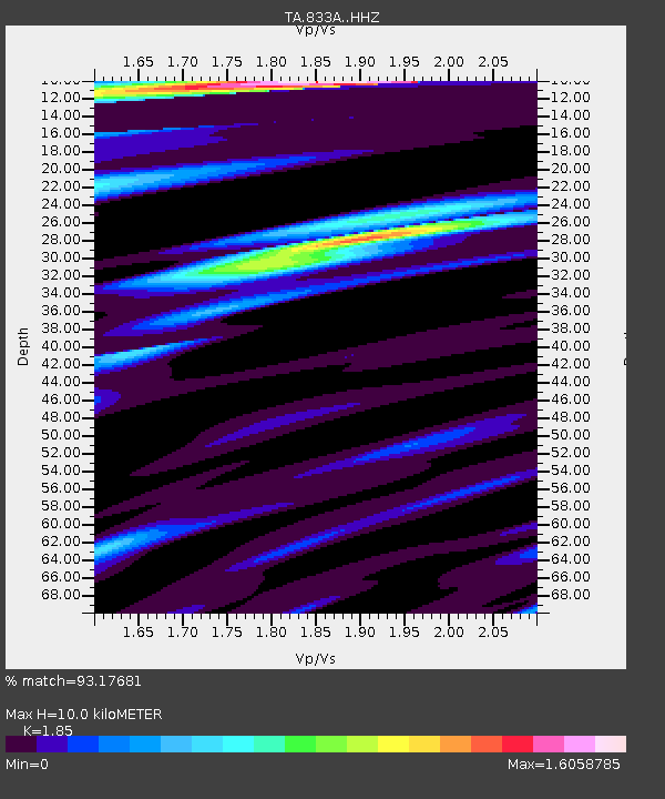
| Estimated Moho Depth: |
10.0 km |
| Estimated Crust Vp/Vs: |
1.85 |
| Assumed Crust Vp: |
6.347 km/s |
| Estimated Crust Vs: |
3.431 km/s |
| Estimated Crust Poisson's Ratio: |
0.29 |
|
| Radial Match: |
93.17681 % |
| Radial Bump: |
324 |
| Transverse Match: |
84.03024 % |
| Transverse Bump: |
400 |
| SOD ConfigId: |
13570011 |
| Insert Time: |
2019-05-01 23:21:45.071 +0000 |
| GWidth: |
2.5 |
| Max Bumps: |
400 |
| Tol: |
0.001 |
|

Signal To Noise
| Channel | StoN | STA | LTA |
| TA:833A: :HHZ:20181130T17:37:24.470006Z | 53.926056 | 1.8513116E-5 | 3.4330557E-7 |
| TA:833A: :HHN:20181130T17:37:24.470006Z | 12.98314 | 6.1997193E-6 | 4.7752076E-7 |
| TA:833A: :HHE:20181130T17:37:24.470006Z | 8.017588 | 4.2659854E-6 | 5.320784E-7 |
| Arrivals |
| Ps | 1.4 SECOND |
| PpPs | 4.2 SECOND |
| PsPs/PpSs | 5.7 SECOND |


