You are here: Home > Network List > TA - USArray Transportable Network (new EarthScope stations) Stations List
> Station L61B Northampton, MA, USA > Earthquake Result Viewer
L61B Northampton, MA, USA - Earthquake Result Viewer
| Earthquake location: |
Southern Alaska |
| Earthquake latitude/longitude: |
61.3/-149.9 |
| Earthquake time(UTC): |
2018/11/30 (334) 17:29:28 GMT |
| Earthquake Depth: |
43 km |
| Earthquake Magnitude: |
6.6 ml |
| Earthquake Catalog/Contributor: |
NEIC PDE/ak |
|
| Network: |
TA USArray Transportable Network (new EarthScope stations) |
| Station: |
L61B Northampton, MA, USA |
| Lat/Lon: |
42.45 N/72.68 W |
| Elevation: |
261 m |
|
| Distance: |
48.1 deg |
| Az: |
75.91 deg |
| Baz: |
320.806 deg |
| Ray Param: |
0.06947914 |
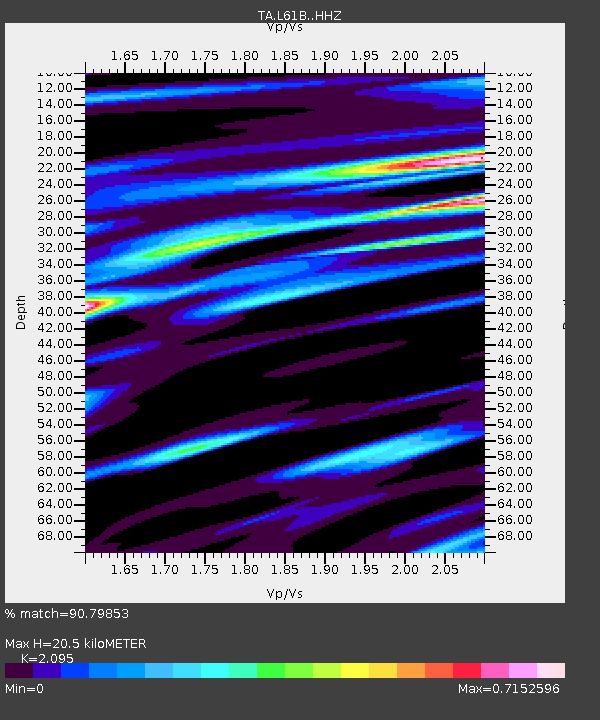
| Estimated Moho Depth: |
20.5 km |
| Estimated Crust Vp/Vs: |
2.10 |
| Assumed Crust Vp: |
6.419 km/s |
| Estimated Crust Vs: |
3.064 km/s |
| Estimated Crust Poisson's Ratio: |
0.35 |
|
| Radial Match: |
90.79853 % |
| Radial Bump: |
289 |
| Transverse Match: |
73.41702 % |
| Transverse Bump: |
400 |
| SOD ConfigId: |
13570011 |
| Insert Time: |
2019-05-01 23:21:45.847 +0000 |
| GWidth: |
2.5 |
| Max Bumps: |
400 |
| Tol: |
0.001 |
|

Signal To Noise
| Channel | StoN | STA | LTA |
| TA:L61B: :HHZ:20181130T17:37:33.919988Z | 8.07817 | 1.1333863E-5 | 1.4030236E-6 |
| TA:L61B: :HHN:20181130T17:37:33.919988Z | 4.7492948 | 5.400865E-6 | 1.1371931E-6 |
| TA:L61B: :HHE:20181130T17:37:33.919988Z | 3.1782181 | 3.1561285E-6 | 9.930498E-7 |
| Arrivals |
| Ps | 3.7 SECOND |
| PpPs | 9.4 SECOND |
| PsPs/PpSs | 13 SECOND |


