You are here: Home > Network List > TA - USArray Transportable Network (new EarthScope stations) Stations List
> Station M65A Busby, Falmouth, MA, USA > Earthquake Result Viewer
M65A Busby, Falmouth, MA, USA - Earthquake Result Viewer
| Earthquake location: |
Southern Alaska |
| Earthquake latitude/longitude: |
61.3/-149.9 |
| Earthquake time(UTC): |
2018/11/30 (334) 17:29:28 GMT |
| Earthquake Depth: |
43 km |
| Earthquake Magnitude: |
6.6 ml |
| Earthquake Catalog/Contributor: |
NEIC PDE/ak |
|
| Network: |
TA USArray Transportable Network (new EarthScope stations) |
| Station: |
M65A Busby, Falmouth, MA, USA |
| Lat/Lon: |
41.56 N/70.65 W |
| Elevation: |
22 m |
|
| Distance: |
49.7 deg |
| Az: |
75.08 deg |
| Baz: |
321.616 deg |
| Ray Param: |
0.06841293 |
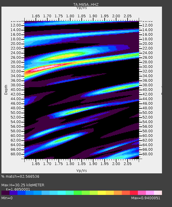
| Estimated Moho Depth: |
30.25 km |
| Estimated Crust Vp/Vs: |
1.69 |
| Assumed Crust Vp: |
6.472 km/s |
| Estimated Crust Vs: |
3.841 km/s |
| Estimated Crust Poisson's Ratio: |
0.23 |
|
| Radial Match: |
82.566536 % |
| Radial Bump: |
400 |
| Transverse Match: |
65.5647 % |
| Transverse Bump: |
400 |
| SOD ConfigId: |
13570011 |
| Insert Time: |
2019-05-01 23:21:47.412 +0000 |
| GWidth: |
2.5 |
| Max Bumps: |
400 |
| Tol: |
0.001 |
|
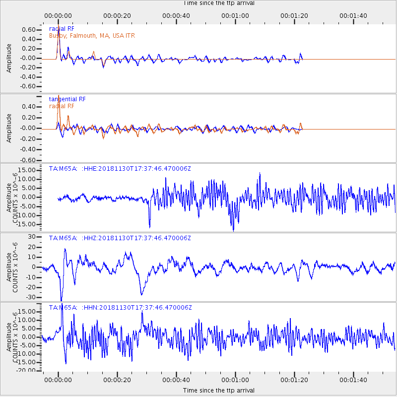
Signal To Noise
| Channel | StoN | STA | LTA |
| TA:M65A: :HHZ:20181130T17:37:46.470006Z | 10.828362 | 1.37427505E-5 | 1.2691439E-6 |
| TA:M65A: :HHN:20181130T17:37:46.470006Z | 6.432485 | 7.654424E-6 | 1.1899637E-6 |
| TA:M65A: :HHE:20181130T17:37:46.470006Z | 4.898395 | 4.75204E-6 | 9.701218E-7 |
| Arrivals |
| Ps | 3.4 SECOND |
| PpPs | 12 SECOND |
| PsPs/PpSs | 15 SECOND |


