You are here: Home > Network List > TA - USArray Transportable Network (new EarthScope stations) Stations List
> Station Q24A Divide, CO, USA > Earthquake Result Viewer
Q24A Divide, CO, USA - Earthquake Result Viewer
| Earthquake location: |
Southern Alaska |
| Earthquake latitude/longitude: |
61.3/-149.9 |
| Earthquake time(UTC): |
2018/11/30 (334) 17:29:28 GMT |
| Earthquake Depth: |
43 km |
| Earthquake Magnitude: |
6.6 ml |
| Earthquake Catalog/Contributor: |
NEIC PDE/ak |
|
| Network: |
TA USArray Transportable Network (new EarthScope stations) |
| Station: |
Q24A Divide, CO, USA |
| Lat/Lon: |
38.96 N/105.15 W |
| Elevation: |
2775 m |
|
| Distance: |
35.4 deg |
| Az: |
108.409 deg |
| Baz: |
324.062 deg |
| Ray Param: |
0.07716645 |
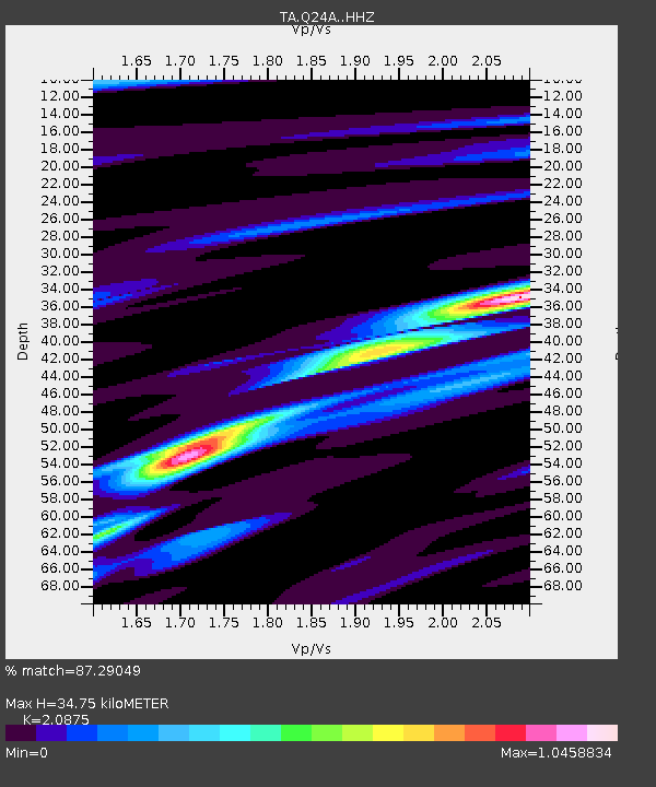
| Estimated Moho Depth: |
34.75 km |
| Estimated Crust Vp/Vs: |
2.09 |
| Assumed Crust Vp: |
6.159 km/s |
| Estimated Crust Vs: |
2.95 km/s |
| Estimated Crust Poisson's Ratio: |
0.35 |
|
| Radial Match: |
87.29049 % |
| Radial Bump: |
217 |
| Transverse Match: |
72.24057 % |
| Transverse Bump: |
400 |
| SOD ConfigId: |
13570011 |
| Insert Time: |
2019-05-01 23:21:49.732 +0000 |
| GWidth: |
2.5 |
| Max Bumps: |
400 |
| Tol: |
0.001 |
|
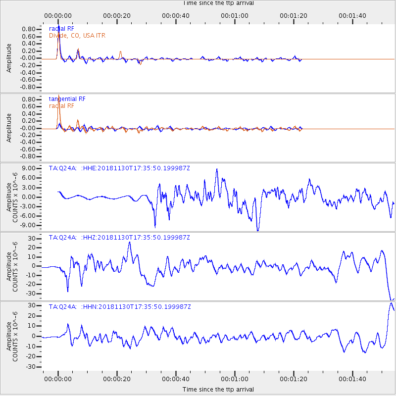
Signal To Noise
| Channel | StoN | STA | LTA |
| TA:Q24A: :HHZ:20181130T17:35:50.199987Z | 12.282108 | 9.28936E-6 | 7.5633267E-7 |
| TA:Q24A: :HHN:20181130T17:35:50.199987Z | 7.0685797 | 5.075274E-6 | 7.180048E-7 |
| TA:Q24A: :HHE:20181130T17:35:50.199987Z | 6.6395497 | 3.321805E-6 | 5.0030576E-7 |
| Arrivals |
| Ps | 6.5 SECOND |
| PpPs | 16 SECOND |
| PsPs/PpSs | 23 SECOND |


