You are here: Home > Network List > TA - USArray Transportable Network (new EarthScope stations) Stations List
> Station I21A Big Trails, Ten Sleep, WY, USA > Earthquake Result Viewer
I21A Big Trails, Ten Sleep, WY, USA - Earthquake Result Viewer

| Earthquake location: |
Kuril Islands |
| Earthquake latitude/longitude: |
50.8/155.0 |
| Earthquake time(UTC): |
2009/04/21 (111) 05:26:11 GMT |
| Earthquake Depth: |
152 km |
| Earthquake Magnitude: |
6.0 MB, 6.2 MW, 6.2 MW |
| Earthquake Catalog/Contributor: |
WHDF/NEIC |
|
| Network: |
TA USArray Transportable Network (new EarthScope stations) |
| Station: |
I21A Big Trails, Ten Sleep, WY, USA |
| Lat/Lon: |
43.81 N/107.29 W |
| Elevation: |
1639 m |
|
| Distance: |
61.8 deg |
| Az: |
54.461 deg |
| Baz: |
314.538 deg |
| Ray Param: |
0.060161415 |
| Estimated Moho Depth: |
69.75 km |
| Estimated Crust Vp/Vs: |
1.61 |
| Assumed Crust Vp: |
6.178 km/s |
| Estimated Crust Vs: |
3.843 km/s |
| Estimated Crust Poisson's Ratio: |
0.18 |
|
| Radial Match: |
91.47944 % |
| Radial Bump: |
396 |
| Transverse Match: |
85.185455 % |
| Transverse Bump: |
400 |
| SOD ConfigId: |
2658 |
| Insert Time: |
2010-03-06 18:24:25.185 +0000 |
| GWidth: |
2.5 |
| Max Bumps: |
400 |
| Tol: |
0.001 |
|
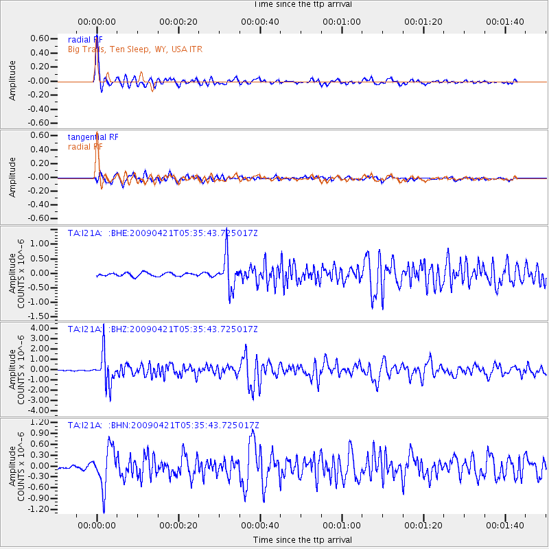
Signal To Noise
| Channel | StoN | STA | LTA |
| TA:I21A: :BHZ:20090421T05:35:43.725017Z | 23.249172 | 1.5335421E-6 | 6.5961146E-8 |
| TA:I21A: :BHN:20090421T05:35:43.725017Z | 7.2751684 | 5.495667E-7 | 7.5540065E-8 |
| TA:I21A: :BHE:20090421T05:35:43.725017Z | 9.797187 | 5.619588E-7 | 5.73592E-8 |
| Arrivals |
| Ps | 7.2 SECOND |
| PpPs | 28 SECOND |
| PsPs/PpSs | 35 SECOND |


