You are here: Home > Network List > TX - Texas Seismological Network Stations List
> Station PH02 Texas Public Hunt System CROSS BAR MGT AREA > Earthquake Result Viewer
PH02 Texas Public Hunt System CROSS BAR MGT AREA - Earthquake Result Viewer
| Earthquake location: |
Southern Alaska |
| Earthquake latitude/longitude: |
61.3/-149.9 |
| Earthquake time(UTC): |
2018/11/30 (334) 17:29:28 GMT |
| Earthquake Depth: |
43 km |
| Earthquake Magnitude: |
6.6 ml |
| Earthquake Catalog/Contributor: |
NEIC PDE/ak |
|
| Network: |
TX Texas Seismological Network |
| Station: |
PH02 Texas Public Hunt System CROSS BAR MGT AREA |
| Lat/Lon: |
35.39 N/101.95 W |
| Elevation: |
1022 m |
|
| Distance: |
39.8 deg |
| Az: |
108.327 deg |
| Baz: |
325.925 deg |
| Ray Param: |
0.07469739 |
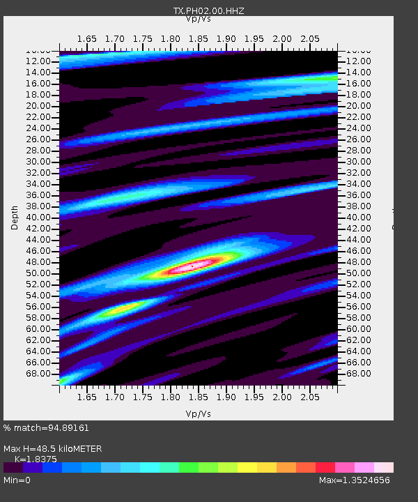
| Estimated Moho Depth: |
48.5 km |
| Estimated Crust Vp/Vs: |
1.84 |
| Assumed Crust Vp: |
6.426 km/s |
| Estimated Crust Vs: |
3.497 km/s |
| Estimated Crust Poisson's Ratio: |
0.29 |
|
| Radial Match: |
94.89161 % |
| Radial Bump: |
307 |
| Transverse Match: |
86.350464 % |
| Transverse Bump: |
400 |
| SOD ConfigId: |
13570011 |
| Insert Time: |
2019-05-01 23:22:14.616 +0000 |
| GWidth: |
2.5 |
| Max Bumps: |
400 |
| Tol: |
0.001 |
|

Signal To Noise
| Channel | StoN | STA | LTA |
| TX:PH02:00:HHZ:20181130T17:36:27.209996Z | 47.272835 | 1.2564069E-5 | 2.657778E-7 |
| TX:PH02:00:HH1:20181130T17:36:27.209996Z | 12.365147 | 5.6030567E-6 | 4.5313303E-7 |
| TX:PH02:00:HH2:20181130T17:36:27.209996Z | 20.15793 | 6.4043215E-6 | 3.177073E-7 |
| Arrivals |
| Ps | 6.8 SECOND |
| PpPs | 20 SECOND |
| PsPs/PpSs | 27 SECOND |


