You are here: Home > Network List > US - United States National Seismic Network Stations List
> Station GLMI Grayling, Michigan, USA > Earthquake Result Viewer
GLMI Grayling, Michigan, USA - Earthquake Result Viewer
| Earthquake location: |
Southern Alaska |
| Earthquake latitude/longitude: |
61.3/-149.9 |
| Earthquake time(UTC): |
2018/11/30 (334) 17:29:28 GMT |
| Earthquake Depth: |
43 km |
| Earthquake Magnitude: |
6.6 ml |
| Earthquake Catalog/Contributor: |
NEIC PDE/ak |
|
| Network: |
US United States National Seismic Network |
| Station: |
GLMI Grayling, Michigan, USA |
| Lat/Lon: |
44.82 N/84.62 W |
| Elevation: |
387 m |
|
| Distance: |
40.6 deg |
| Az: |
83.086 deg |
| Baz: |
317.723 deg |
| Ray Param: |
0.07417949 |
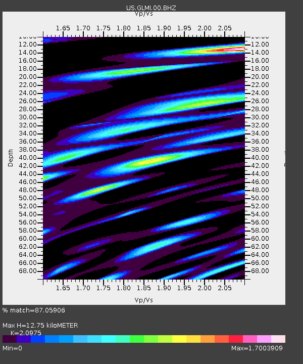
| Estimated Moho Depth: |
12.75 km |
| Estimated Crust Vp/Vs: |
2.10 |
| Assumed Crust Vp: |
6.483 km/s |
| Estimated Crust Vs: |
3.091 km/s |
| Estimated Crust Poisson's Ratio: |
0.35 |
|
| Radial Match: |
87.05906 % |
| Radial Bump: |
400 |
| Transverse Match: |
71.32728 % |
| Transverse Bump: |
400 |
| SOD ConfigId: |
13570011 |
| Insert Time: |
2019-05-01 23:22:22.698 +0000 |
| GWidth: |
2.5 |
| Max Bumps: |
400 |
| Tol: |
0.001 |
|

Signal To Noise
| Channel | StoN | STA | LTA |
| US:GLMI:00:BHZ:20181130T17:36:34.523992Z | 13.295067 | 2.1577895E-5 | 1.6230001E-6 |
| US:GLMI:00:BH1:20181130T17:36:34.523992Z | 14.6455 | 1.5399068E-5 | 1.0514539E-6 |
| US:GLMI:00:BH2:20181130T17:36:34.523992Z | 8.335088 | 1.3771373E-5 | 1.652217E-6 |
| Arrivals |
| Ps | 2.3 SECOND |
| PpPs | 5.7 SECOND |
| PsPs/PpSs | 8.0 SECOND |


