You are here: Home > Network List > CI - Caltech Regional Seismic Network Stations List
> Station MPM Manuel Prospect Mine, California, USA > Earthquake Result Viewer
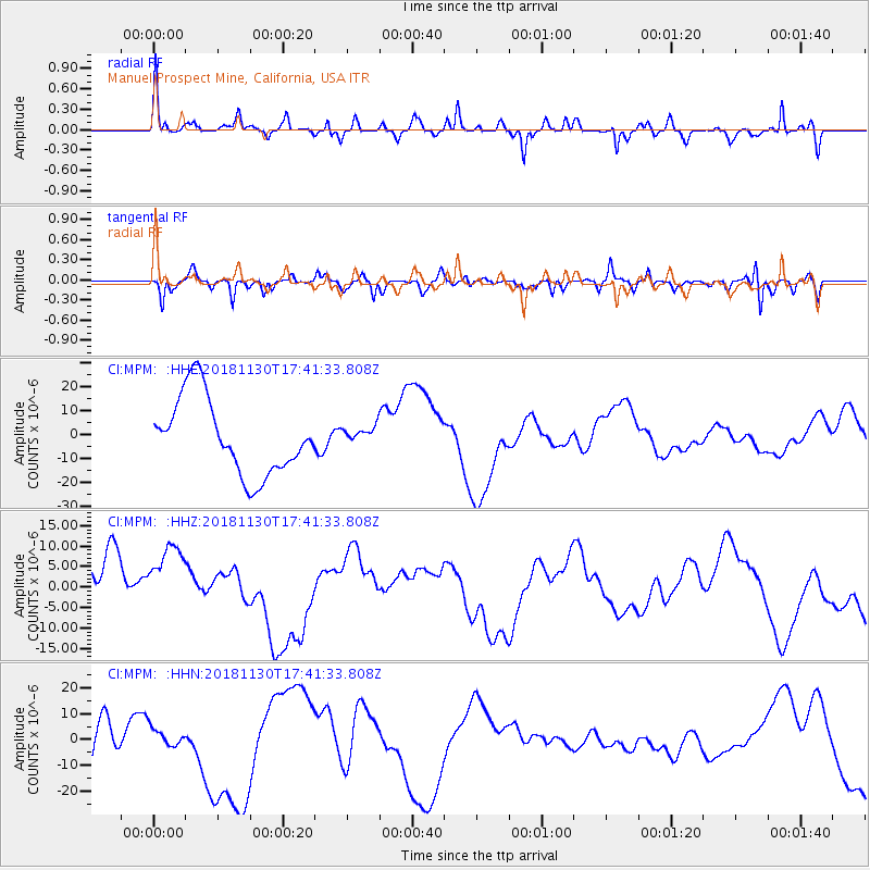
MPM Manuel Prospect Mine, California, USA - Earthquake Result Viewer
*The percent match for this event was below the threshold and hence no stack was calculated.
| Earthquake location: |
Southern Alaska |
| Earthquake latitude/longitude: |
61.2/-149.9 |
| Earthquake time(UTC): |
2018/11/30 (334) 17:35:37 GMT |
| Earthquake Depth: |
39 km |
| Earthquake Magnitude: |
5.8 Ml |
| Earthquake Catalog/Contributor: |
NEIC PDE/ak |
|
| Network: |
CI Caltech Regional Seismic Network |
| Station: |
MPM Manuel Prospect Mine, California, USA |
| Lat/Lon: |
36.06 N/117.49 W |
| Elevation: |
185 m |
|
| Distance: |
32.4 deg |
| Az: |
125.943 deg |
| Baz: |
331.048 deg |
| Ray Param: |
$rayparam |
*The percent match for this event was below the threshold and hence was not used in the summary stack. |
|
| Radial Match: |
42.65343 % |
| Radial Bump: |
297 |
| Transverse Match: |
62.740063 % |
| Transverse Bump: |
336 |
| SOD ConfigId: |
13570011 |
| Insert Time: |
2019-05-01 23:25:07.506 +0000 |
| GWidth: |
2.5 |
| Max Bumps: |
400 |
| Tol: |
0.001 |
|
Signal To Noise
| Channel | StoN | STA | LTA |
| CI:MPM: :HHZ:20181130T17:41:33.808Z | 1.3084279 | 9.986068E-6 | 7.632112E-6 |
| CI:MPM: :HHN:20181130T17:41:33.808Z | 0.27444652 | 3.8106457E-6 | 1.3884839E-5 |
| CI:MPM: :HHE:20181130T17:41:33.808Z | 0.20528762 | 3.265308E-6 | 1.5906015E-5 |
| Arrivals |
| Ps | |
| PpPs | |
| PsPs/PpSs | |


