You are here: Home > Network List > CI - Caltech Regional Seismic Network Stations List
> Station SWS Sam W. Stewart, Westmorland, CA, USA > Earthquake Result Viewer
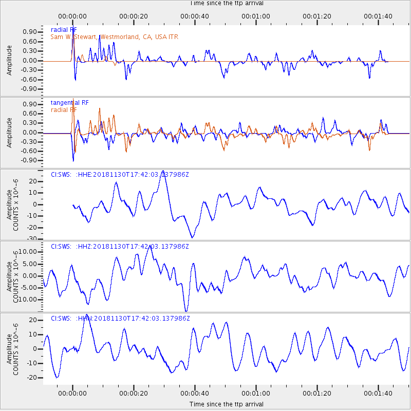
SWS Sam W. Stewart, Westmorland, CA, USA - Earthquake Result Viewer
*The percent match for this event was below the threshold and hence no stack was calculated.
| Earthquake location: |
Southern Alaska |
| Earthquake latitude/longitude: |
61.2/-149.9 |
| Earthquake time(UTC): |
2018/11/30 (334) 17:35:37 GMT |
| Earthquake Depth: |
39 km |
| Earthquake Magnitude: |
5.8 Ml |
| Earthquake Catalog/Contributor: |
NEIC PDE/ak |
|
| Network: |
CI Caltech Regional Seismic Network |
| Station: |
SWS Sam W. Stewart, Westmorland, CA, USA |
| Lat/Lon: |
32.94 N/115.80 W |
| Elevation: |
140 m |
|
| Distance: |
35.8 deg |
| Az: |
126.376 deg |
| Baz: |
332.361 deg |
| Ray Param: |
$rayparam |
*The percent match for this event was below the threshold and hence was not used in the summary stack. |
|
| Radial Match: |
64.79836 % |
| Radial Bump: |
309 |
| Transverse Match: |
55.26512 % |
| Transverse Bump: |
334 |
| SOD ConfigId: |
13570011 |
| Insert Time: |
2019-05-01 23:25:20.922 +0000 |
| GWidth: |
2.5 |
| Max Bumps: |
400 |
| Tol: |
0.001 |
|
Signal To Noise
| Channel | StoN | STA | LTA |
| CI:SWS: :HHZ:20181130T17:42:03.137986Z | 2.138795 | 6.868353E-6 | 3.211319E-6 |
| CI:SWS: :HHN:20181130T17:42:03.137986Z | 1.1399144 | 1.23501695E-5 | 1.0834295E-5 |
| CI:SWS: :HHE:20181130T17:42:03.137986Z | 2.5025234 | 1.835094E-5 | 7.3329747E-6 |
| Arrivals |
| Ps | |
| PpPs | |
| PsPs/PpSs | |


