You are here: Home > Network List > TA - USArray Transportable Network (new EarthScope stations) Stations List
> Station I21A Big Trails, Ten Sleep, WY, USA > Earthquake Result Viewer
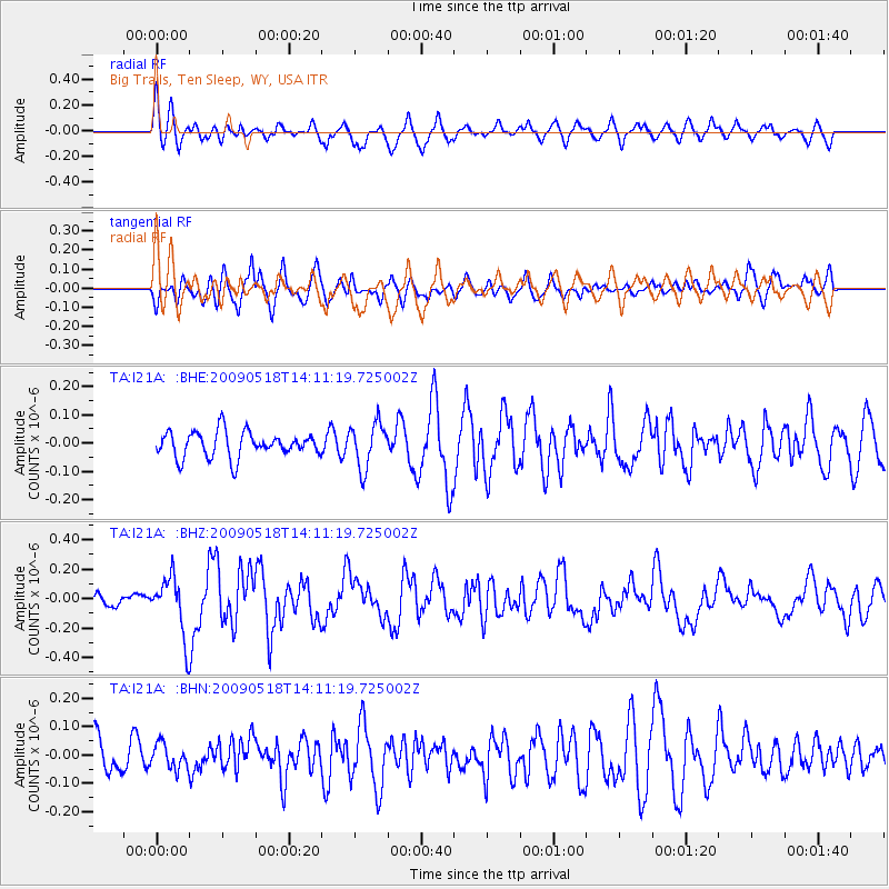
I21A Big Trails, Ten Sleep, WY, USA - Earthquake Result Viewer
*The percent match for this event was below the threshold and hence no stack was calculated.
| Earthquake location: |
Near Coast Of Peru |
| Earthquake latitude/longitude: |
-15.7/-74.8 |
| Earthquake time(UTC): |
2009/05/18 (138) 14:01:04 GMT |
| Earthquake Depth: |
23 km |
| Earthquake Magnitude: |
5.5 MS, 5.3 MB, 5.8 MW, 5.8 MW |
| Earthquake Catalog/Contributor: |
WHDF/NEIC |
|
| Network: |
TA USArray Transportable Network (new EarthScope stations) |
| Station: |
I21A Big Trails, Ten Sleep, WY, USA |
| Lat/Lon: |
43.81 N/107.29 W |
| Elevation: |
1639 m |
|
| Distance: |
66.2 deg |
| Az: |
334.877 deg |
| Baz: |
145.599 deg |
| Ray Param: |
$rayparam |
*The percent match for this event was below the threshold and hence was not used in the summary stack. |
|
| Radial Match: |
67.06255 % |
| Radial Bump: |
400 |
| Transverse Match: |
58.145134 % |
| Transverse Bump: |
400 |
| SOD ConfigId: |
2760 |
| Insert Time: |
2010-03-06 18:25:19.638 +0000 |
| GWidth: |
2.5 |
| Max Bumps: |
400 |
| Tol: |
0.001 |
|
Signal To Noise
| Channel | StoN | STA | LTA |
| TA:I21A: :BHZ:20090518T14:11:19.725002Z | 5.163967 | 1.9935987E-7 | 3.860595E-8 |
| TA:I21A: :BHN:20090518T14:11:19.725002Z | 0.53287566 | 4.316512E-8 | 8.100412E-8 |
| TA:I21A: :BHE:20090518T14:11:19.725002Z | 1.7687433 | 7.9391825E-8 | 4.4886008E-8 |
| Arrivals |
| Ps | |
| PpPs | |
| PsPs/PpSs | |


