You are here: Home > Network List > TA - USArray Transportable Network (new EarthScope stations) Stations List
> Station T25A Trinidad, CO, USA > Earthquake Result Viewer
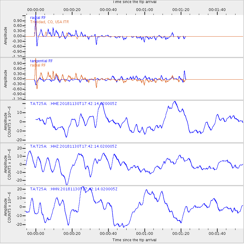
T25A Trinidad, CO, USA - Earthquake Result Viewer
*The percent match for this event was below the threshold and hence no stack was calculated.
| Earthquake location: |
Southern Alaska |
| Earthquake latitude/longitude: |
61.2/-149.9 |
| Earthquake time(UTC): |
2018/11/30 (334) 17:35:37 GMT |
| Earthquake Depth: |
39 km |
| Earthquake Magnitude: |
5.8 Ml |
| Earthquake Catalog/Contributor: |
NEIC PDE/ak |
|
| Network: |
TA USArray Transportable Network (new EarthScope stations) |
| Station: |
T25A Trinidad, CO, USA |
| Lat/Lon: |
37.14 N/104.41 W |
| Elevation: |
2017 m |
|
| Distance: |
37.1 deg |
| Az: |
109.26 deg |
| Baz: |
325.085 deg |
| Ray Param: |
$rayparam |
*The percent match for this event was below the threshold and hence was not used in the summary stack. |
|
| Radial Match: |
40.08857 % |
| Radial Bump: |
349 |
| Transverse Match: |
53.47267 % |
| Transverse Bump: |
400 |
| SOD ConfigId: |
13570011 |
| Insert Time: |
2019-05-01 23:30:10.243 +0000 |
| GWidth: |
2.5 |
| Max Bumps: |
400 |
| Tol: |
0.001 |
|
Signal To Noise
| Channel | StoN | STA | LTA |
| TA:T25A: :HHZ:20181130T17:42:14.020005Z | 1.2103682 | 6.2292474E-6 | 5.146572E-6 |
| TA:T25A: :HHN:20181130T17:42:14.020005Z | 0.83265996 | 8.098161E-6 | 9.725652E-6 |
| TA:T25A: :HHE:20181130T17:42:14.020005Z | 1.4146442 | 7.737809E-6 | 5.4697916E-6 |
| Arrivals |
| Ps | |
| PpPs | |
| PsPs/PpSs | |


