You are here: Home > Network List > TS - TERRAscope (Southern California Seismic Network) Stations List
> Station BAR Barrett Dam, California, USA > Earthquake Result Viewer
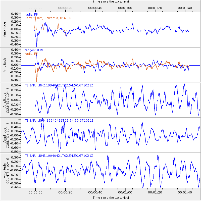
BAR Barrett Dam, California, USA - Earthquake Result Viewer
*The percent match for this event was below the threshold and hence no stack was calculated.
| Earthquake location: |
Solomon Islands |
| Earthquake latitude/longitude: |
-5.6/154.1 |
| Earthquake time(UTC): |
1994/04/21 (111) 02:42:15 GMT |
| Earthquake Depth: |
39 km |
| Earthquake Magnitude: |
5.4 MB, 5.6 MS |
| Earthquake Catalog/Contributor: |
WHDF/NEIC |
|
| Network: |
TS TERRAscope (Southern California Seismic Network) |
| Station: |
BAR Barrett Dam, California, USA |
| Lat/Lon: |
32.68 N/116.67 W |
| Elevation: |
548 m |
|
| Distance: |
92.4 deg |
| Az: |
57.565 deg |
| Baz: |
264.895 deg |
| Ray Param: |
$rayparam |
*The percent match for this event was below the threshold and hence was not used in the summary stack. |
|
| Radial Match: |
63.089443 % |
| Radial Bump: |
400 |
| Transverse Match: |
64.702934 % |
| Transverse Bump: |
400 |
| SOD ConfigId: |
4480 |
| Insert Time: |
2010-02-26 14:01:28.684 +0000 |
| GWidth: |
2.5 |
| Max Bumps: |
400 |
| Tol: |
0.001 |
|
Signal To Noise
| Channel | StoN | STA | LTA |
| TS:BAR: :BHN:19940421T02:54:50.671021Z | 2.7912564 | 3.6553615E-7 | 1.3095757E-7 |
| TS:BAR: :BHE:19940421T02:54:50.671021Z | 1.5611233 | 1.4755672E-7 | 9.4519585E-8 |
| TS:BAR: :BHZ:19940421T02:54:50.671021Z | 0.7840749 | 1.2690057E-7 | 1.6184752E-7 |
| Arrivals |
| Ps | |
| PpPs | |
| PsPs/PpSs | |


