You are here: Home > Network List > CB - China National Seismic Network Stations List
> Station GTA Gaotai,Gansu Province > Earthquake Result Viewer
GTA Gaotai,Gansu Province - Earthquake Result Viewer
| Earthquake location: |
Banda Sea |
| Earthquake latitude/longitude: |
-7.4/128.7 |
| Earthquake time(UTC): |
2018/12/01 (335) 13:27:21 GMT |
| Earthquake Depth: |
141 km |
| Earthquake Magnitude: |
6.3 Mww |
| Earthquake Catalog/Contributor: |
NEIC PDE/us |
|
| Network: |
CB China National Seismic Network |
| Station: |
GTA Gaotai,Gansu Province |
| Lat/Lon: |
39.40 N/99.82 E |
| Elevation: |
1345 m |
|
| Distance: |
53.7 deg |
| Az: |
332.324 deg |
| Baz: |
143.522 deg |
| Ray Param: |
0.06545915 |
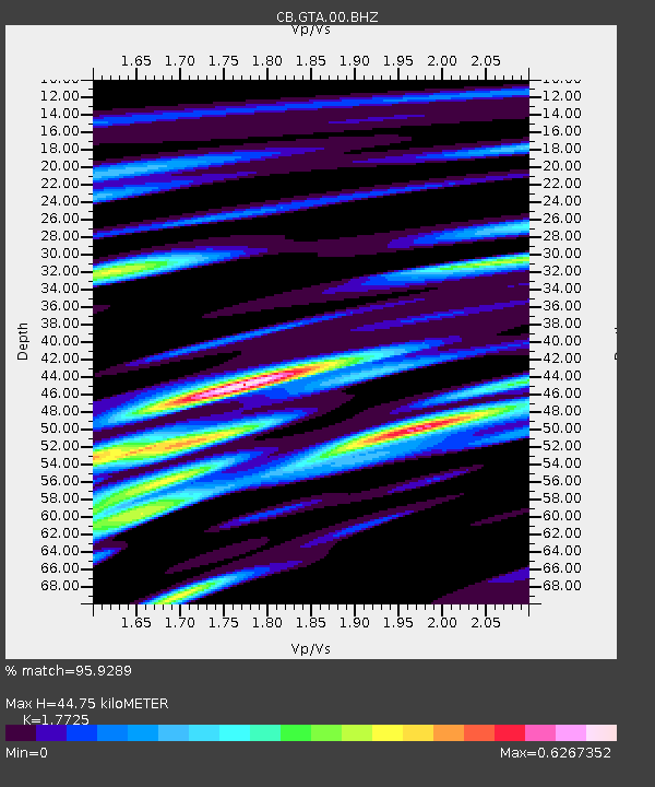
| Estimated Moho Depth: |
44.75 km |
| Estimated Crust Vp/Vs: |
1.77 |
| Assumed Crust Vp: |
6.491 km/s |
| Estimated Crust Vs: |
3.662 km/s |
| Estimated Crust Poisson's Ratio: |
0.27 |
|
| Radial Match: |
95.9289 % |
| Radial Bump: |
303 |
| Transverse Match: |
88.011505 % |
| Transverse Bump: |
400 |
| SOD ConfigId: |
13570011 |
| Insert Time: |
2019-05-01 23:36:45.283 +0000 |
| GWidth: |
2.5 |
| Max Bumps: |
400 |
| Tol: |
0.001 |
|

Signal To Noise
| Channel | StoN | STA | LTA |
| CB:GTA:00:BHZ:20181201T13:35:58.24999Z | 112.983444 | 3.8641806E-6 | 3.42013E-8 |
| CB:GTA:00:BHN:20181201T13:35:58.24999Z | 63.499054 | 1.4273763E-6 | 2.2478703E-8 |
| CB:GTA:00:BHE:20181201T13:35:58.24999Z | 39.56996 | 1.0909997E-6 | 2.7571412E-8 |
| Arrivals |
| Ps | 5.6 SECOND |
| PpPs | 18 SECOND |
| PsPs/PpSs | 24 SECOND |


