You are here: Home > Network List > CB - China National Seismic Network Stations List
> Station SNY Shenyang,Liaoning Province > Earthquake Result Viewer
SNY Shenyang,Liaoning Province - Earthquake Result Viewer
| Earthquake location: |
Banda Sea |
| Earthquake latitude/longitude: |
-7.4/128.7 |
| Earthquake time(UTC): |
2018/12/01 (335) 13:27:21 GMT |
| Earthquake Depth: |
141 km |
| Earthquake Magnitude: |
6.3 Mww |
| Earthquake Catalog/Contributor: |
NEIC PDE/us |
|
| Network: |
CB China National Seismic Network |
| Station: |
SNY Shenyang,Liaoning Province |
| Lat/Lon: |
41.83 N/123.58 E |
| Elevation: |
54 m |
|
| Distance: |
49.2 deg |
| Az: |
354.935 deg |
| Baz: |
173.272 deg |
| Ray Param: |
0.068362 |
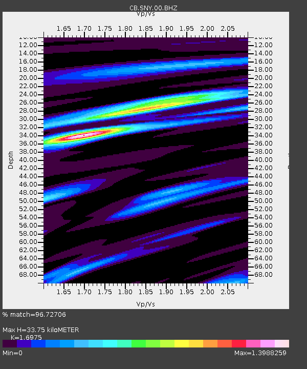
| Estimated Moho Depth: |
33.75 km |
| Estimated Crust Vp/Vs: |
1.70 |
| Assumed Crust Vp: |
6.464 km/s |
| Estimated Crust Vs: |
3.808 km/s |
| Estimated Crust Poisson's Ratio: |
0.23 |
|
| Radial Match: |
96.72706 % |
| Radial Bump: |
341 |
| Transverse Match: |
75.01664 % |
| Transverse Bump: |
400 |
| SOD ConfigId: |
13570011 |
| Insert Time: |
2019-05-01 23:36:53.254 +0000 |
| GWidth: |
2.5 |
| Max Bumps: |
400 |
| Tol: |
0.001 |
|

Signal To Noise
| Channel | StoN | STA | LTA |
| CB:SNY:00:BHZ:20181201T13:35:24.890005Z | 21.743687 | 1.8008759E-6 | 8.2822936E-8 |
| CB:SNY:00:BHN:20181201T13:35:24.890005Z | 11.847372 | 9.190384E-7 | 7.757319E-8 |
| CB:SNY:00:BHE:20181201T13:35:24.890005Z | 1.6542866 | 1.8729676E-7 | 1.1321905E-7 |
| Arrivals |
| Ps | 3.9 SECOND |
| PpPs | 13 SECOND |
| PsPs/PpSs | 17 SECOND |


